
The Niagara Glen Trail & Nature Centre is a fantastic attraction in Niagara Falls, Ontario. Here's our complete visitor's guide - with hiking info!

You know, back in October. Whoops!
Anyway, the STUNNING Niagara Glen is a popular destination in Southern Ontario, not too far from the famous Horseshoe Falls.
It’s been on my bucket list for a while now, as everything I heard about it made it sounds like a dream for nature lovers.
It has a bit of everything - several miles of trails, lots of interesting geology - including prehistoric geological formations and fossils - views from both above and almost down at the water level of the Niagara Gorge, and more.
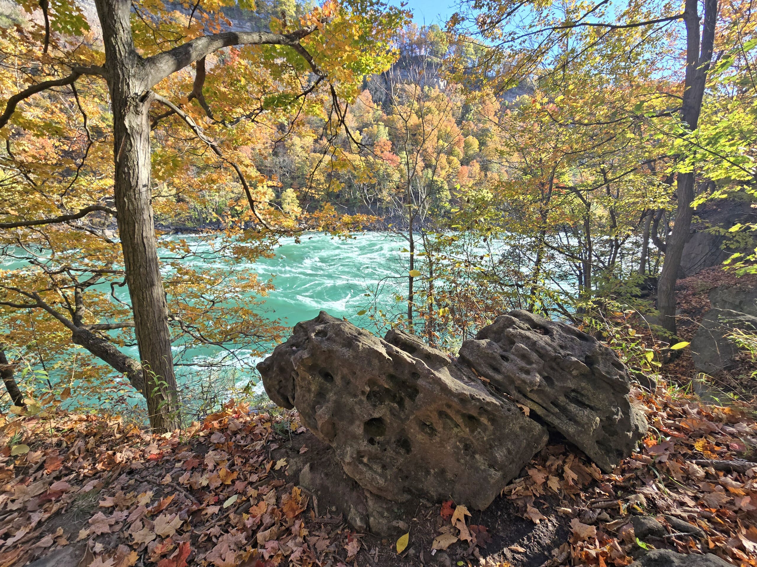
As you may remember from that White Water Walk post... I CANNOT get enough of those gorgeous turquoise waters that tumble through the gorge. Gorge-OUS, more like!
There’s also a Nature Centre - that offers a unique self-guided hiking experience (more on that in a bit!) - sprawling picnic grounds, and more!
We’d only planned a short trip our first visit to check out the Niagara Glen hike, but after discovering what a unique spot of beauty it was, we’re definitely planning for a full day trip.
Our first time there was long after the summer season had wrapped up - JUST after the peak season for fall leaves.
Maybe next time we’ll time it a bit better - I bet it’s STUNNING at the height of fall colours... and hey, fall is the best time for a hike anyway, right?
Anyway, so much to talk about, so let’s get to it!
The Basics:
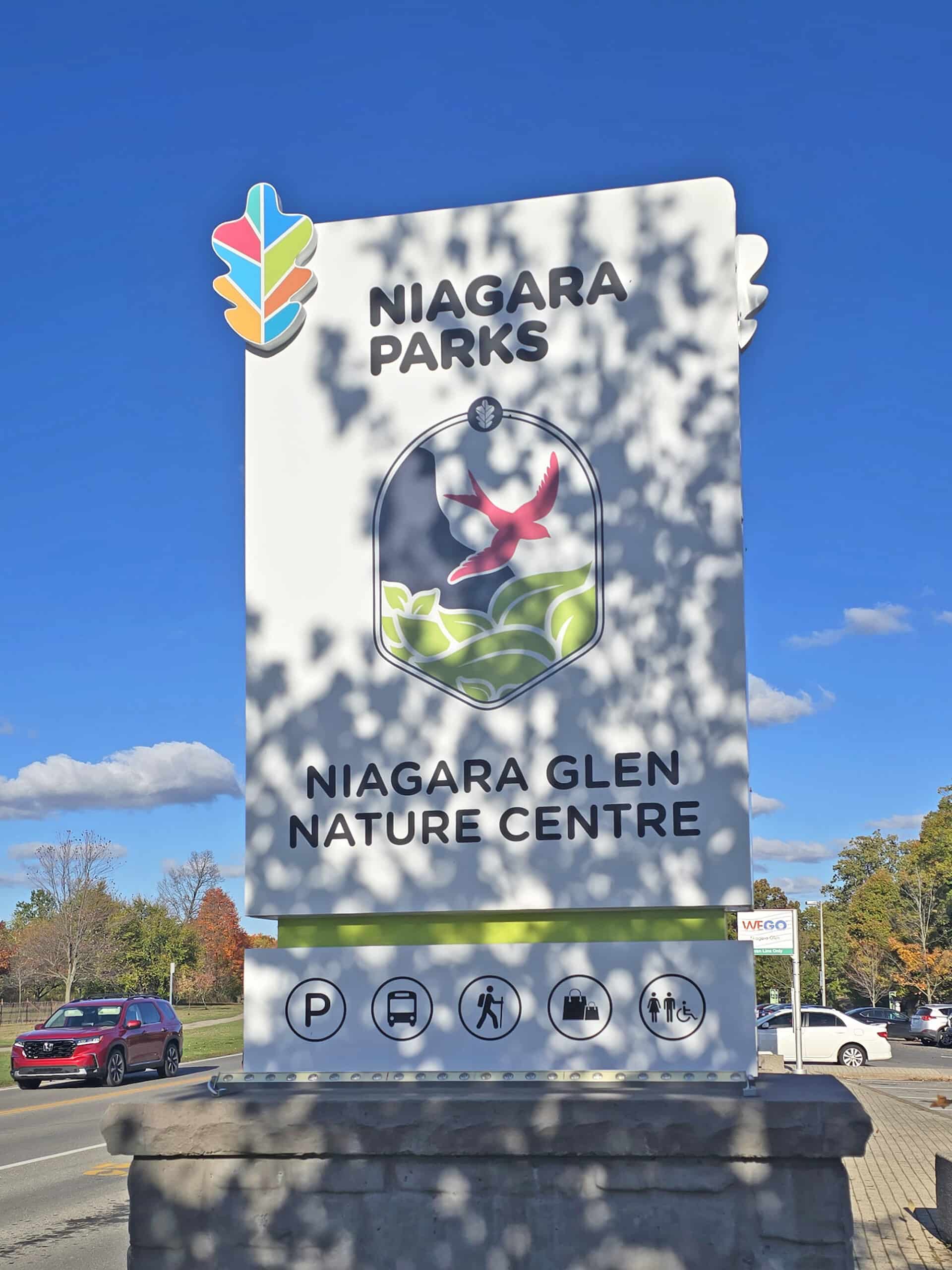
Location Name: Niagara Glen Nature Reserve
Address: 3050 Niagara Parkway, Niagara Falls, ON L2E 6T2
Website: Niagara Parks Commission - Niagara Glen Nature Centre
Price: Free to visit, but parking fees may apply.
Reservations: Generally not required. Call (905) 354-6678 to book guided hikes, or (877) 642-7275 to reserve picnic shelters.
Logistics
Some basic information to help you plan your visit to the Niagara Glen Trails.
Registration and Check In
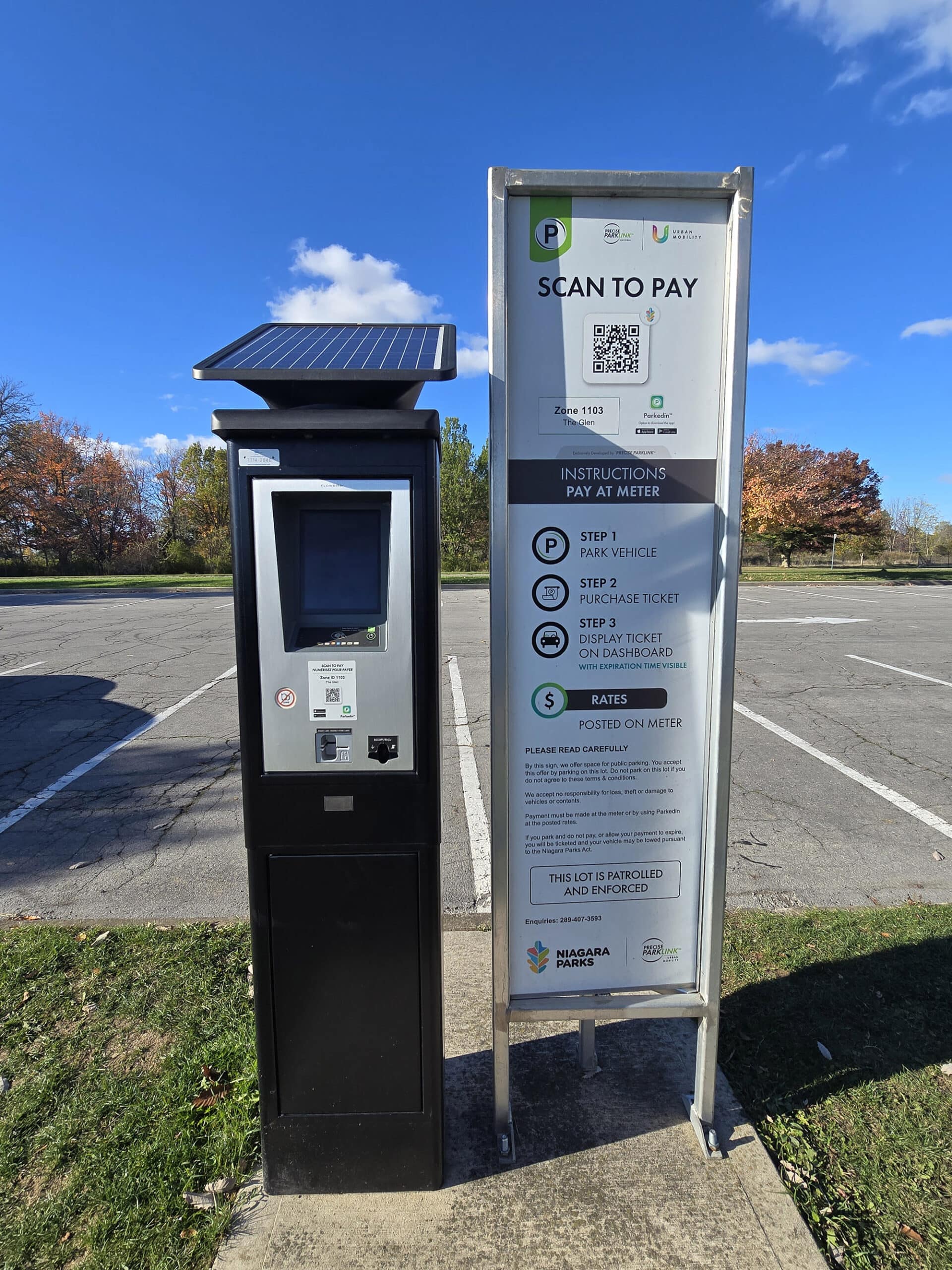
There’s no admission fee to visit the Niagara Glen, just parking fees.
You don't have to book parking in advance - I didn’t even see an option to - you just show up and pay for parking on the spot.
There are machines throughout the parking lot to do so.
Parking
There’s a large parking lot right in front the nature centre, and it stretches for a good chunk of the picnic area. There’s got to be at least a hundred spots, but I didn’t count.
It was probably only a quarter full when we went - at the height of peak colour season - but we did go on a weekday. I think we paid $8/hour.
Apparently there is free parking available, but we didn’t see it. You can check the Parking Locations at Niagara Parks page for more details on parking at their attractions.
Beyond that - if you’re going to be in the area often - an annual parking pass is available. For $50 you can get one that covers all of the Niagara Parks lots, or for $30 you can get one that’s specific to the Niagara Glen.
The whole-park one can be purchased Online, but site-specific ones need to be purchased in person.
Public Transit
Alternately, there’s a WeGO bus stop right in front of the Nature Centre.
We’ve never taken it, but it looks like it’s only a northbound bus... but you’d get on there and it’ll loop around not to far from the parking lot.

Washrooms
There are two options for washrooms at Niagara Glen.
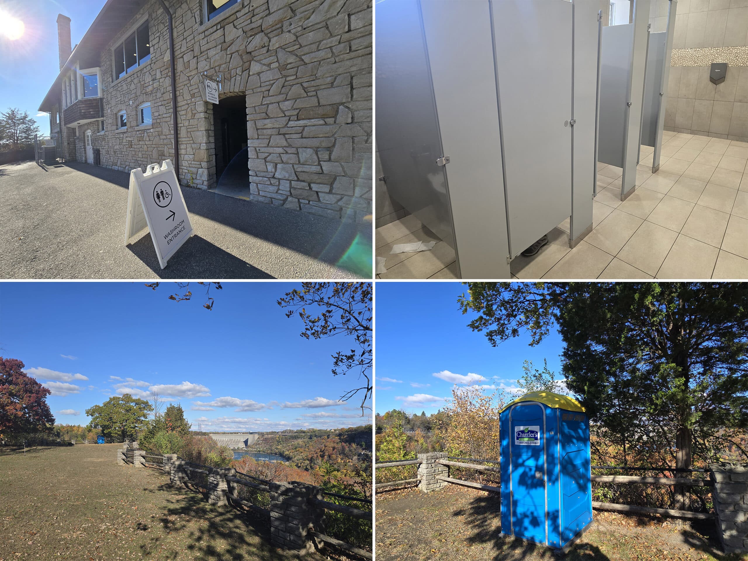
As far as nicer, indoor ones, there are a set of washrooms on the back of the Nature Centre building.
There’s a sloping, paved path to get down to it, and there are separate entrances for the mens’ washroom, and the women’s washroom. (There’s an all-gender / wheelchair accessible one in entrance with the women’s washrooms).
At the time of our visit, the men's washroom was out of order, so they used the all-gender one.
Having all the men have to wait for one single stall was kind of ridiculous, IMHO.
Anyway, in addition to the indoor washrooms, there’s a single porta potty at the far end of the picnic area.
Maps and Signage
Some information to help you find your way around Niagara Glen:
Signage
The directional signage could be better. We didn’t see anything in the parking lot directing us to the start of the trails.
After we’d found the metal staircase that went down to the trails - Porter going down to hike the trails, and me heading back to wander the upper park area - I DID find a map.
It was on a sign stand near the parking lot, but facing away from the parking lot. The map itself was small - but more on that in a bit.
The only real directional signage from then parking lot was to the washroom.
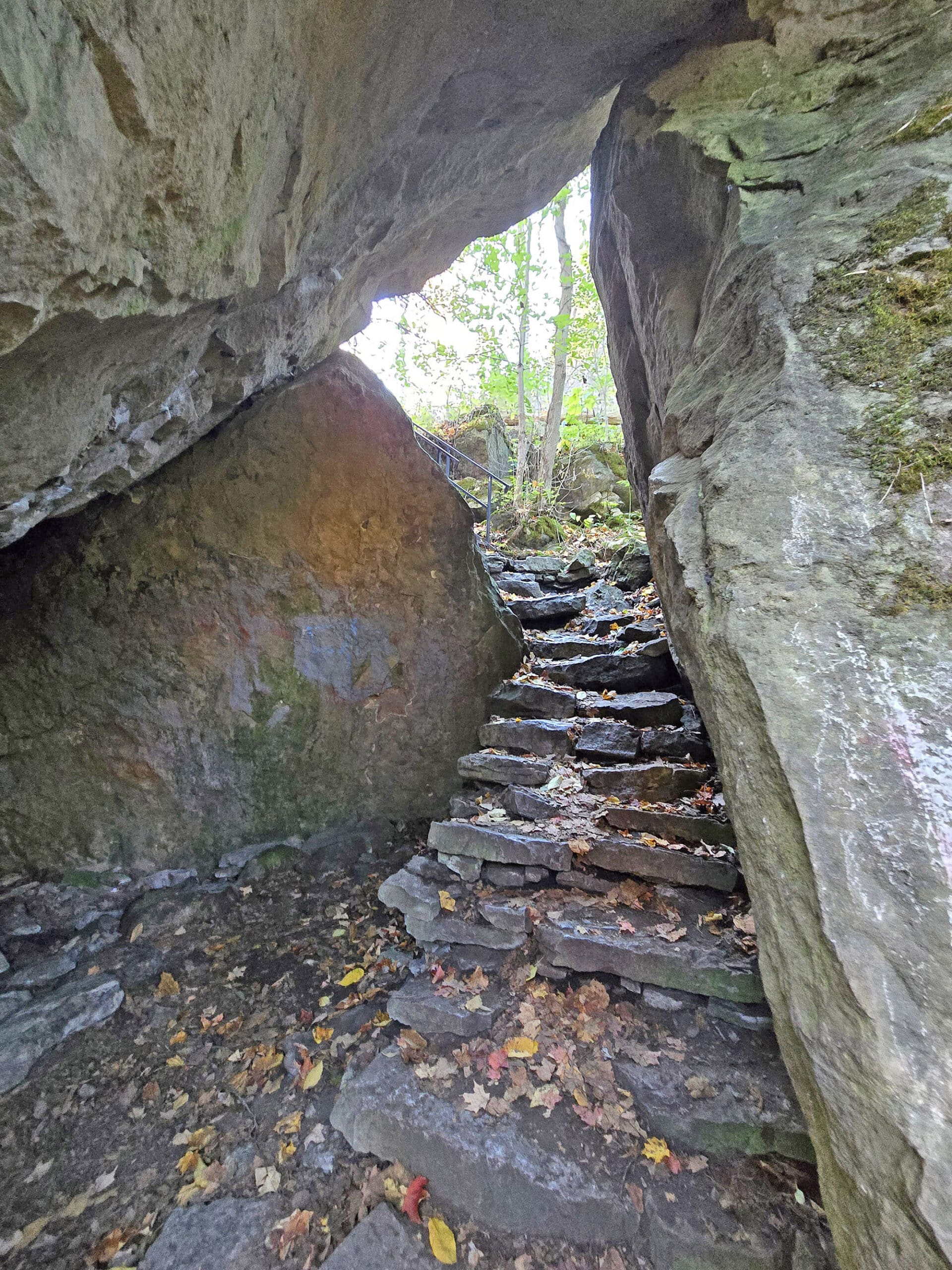
That said, once you get down to the base of the stairs, things are more clear. Overall, these are well-marked trails, with colour-coded blazes.
Each of the trail junctions are especially well marked - and there are some areas that could be blazed better - but you shouldn’t get lost down there.
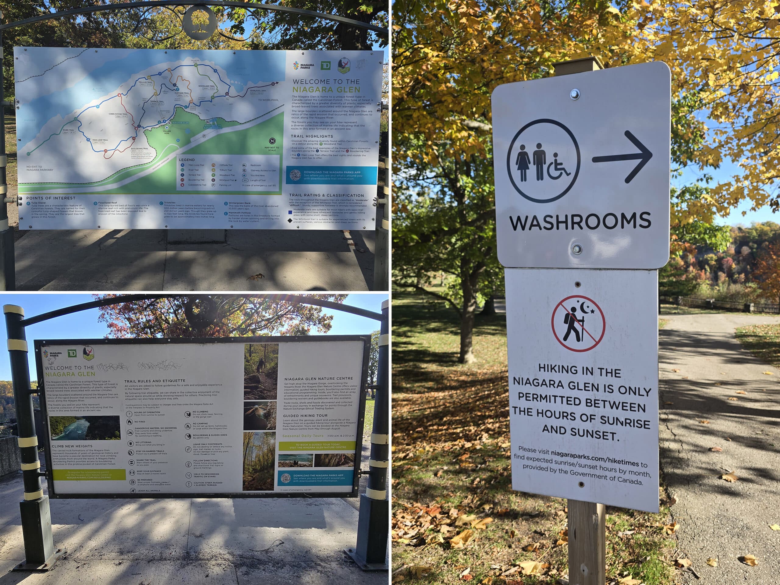
Park Map
The park map situation was a bit ...weird.
There were two very different maps - one near the parking lot, and one near the top of the stairs. There’s also a downloadable Niagara Glen Trail Map, that’s a bit different yet.
As far as the on-site maps go....the one near the stairs seemed more recent, so we're assuming it's more accurate.

It had stairs pictured on the map - the new one did not - and had more points of interest, denoted by numbers.
The new map had fewer points of interest marked in the legend - using letters - but most or all of the points of interest listed on the older map were labeled on the new map itself, rather than in the legend.
It also had more named trails, and the shape of some of the trails were very different than presented on the other map.

1. The picnic area is shown on the older map, but not the newer map.
2. The Porta Potty isn’t shown on either map.
3. None of the maps show steep areas and such, but the online and newer versions of the map show topographical lines, so you can kind of approximate trail elevations from that. In general, trails in the glen feature elevation changes of 60 metres / 200 feet.
Regardless of which map you’re using, though, the trail sections are all colour coded, and pretty easy to differentiate. Sure, the trails don’t all line up to reality, but you get an idea.
If you use the map closest to the stairs, the names, colours, and map DO line up with what you’ll see down there. Mostly.
What wasn’t reflected on the map - or any signage at the start of the trails - is that several trails / trail sections were closed at the time.
The Whirlpool Trail was closed off entirely, and there was a section of the Terrace Trail (between the Cobblestone and Trillium Trails) that were blocked off as well.
This was for trail maintenance, but had no information about when that would be completed.
Accessibility
If you’re looking to visit the Niagara Glen for a picnic - or to visit the Nature Centre itself - it’s pretty accessible.
The path down to the washrooms is wheelchair accessible, and - as mentioned - there’s a barrier free washroom.
It wasn’t super accessible at the time, as that single stall was also serving as the gender-neutral bathroom AND the men’s washroom... so there was a long line.
The Nature Centre is wheelchair accessible, and there are 6 accessible parking spots out front. 2 of those are van accessible spots.
The trail through the picnic area - as well as a longer path extending from the right side of the parking lot (when looking out towards the building / park area) are also wheelchair accessible.
The entire trail system is at the bottom of a large set of stairs (80 steps), and the rest of the rugged trails cover steep terrain, slippery rocks, some infrequent obstacles, etc.
If you’re able to get down the first set of stairs, you MIGHT be able to do the trails, though - Porter says the stairs were the most challenging part.
That said, there are a LOT of stairs along the trail system, too.
Pets
Weirdly, I didn't see a single sign that had anything to do with pets at all.
Usually, you’ll either see one that says you have to keep your dogs leashed and /or pick up after them .... or you'll see signs that say no pets allowed.
That said, there were a ton of people walking their dogs in the main park area above, and Porter saw people walking dogs on the trail below.
As it turns out, yes, dogs are explicitly allowed at Niagara Glen - but they do have to be leashed at all times.
Park Store
There’s a small gift shop in the Nature Centre. It’s cute - very boutique-y. There are some unique souvenirs, clothing items, an array of refreshments. Definitely some snack foods, and - if I remember correctly - I’m pretty sure there were some cold drinks there, too.
(I guess I didn’t take a photo of the area that I remember seeing them in!)
It’s also where you can buy an annual parking pass for the Niagara Glen, sign up for guided hiking tours, get a bouldering permit, etc.

Visitor Centre
At the time of our visit, the Nature Centre was open daily, and it was SUPER cute!
As you enter the building, there’s a wide open area with a big window, and seating with a beautiful view down over the gorge.
This is also where the gift shop is, as well as kind of a welcome desk set up, with visitor information for the Niagara region.
I didn’t know about it at the time, but there’s a self-guided audio tour hike of the Niagara Glen. You don’t need to go into the Nature Centre for it, but hey... this seems like the best place to mention it!
Named “Rekindling All Our Relations”, it’s an app that you can download either from Apple or Google.
It’s an Indigenous audio tour of the Niagara Glen, and it sounds really interesting. Apparently if you have your location services turned on and working, the app will know what area you’re in, and tell you what you’re looking at!
At least, according to the Apple listing.
Anyway, there’s also a bunch of exhibits and such in the Nature Centre, but I’ll get into that in a bit.

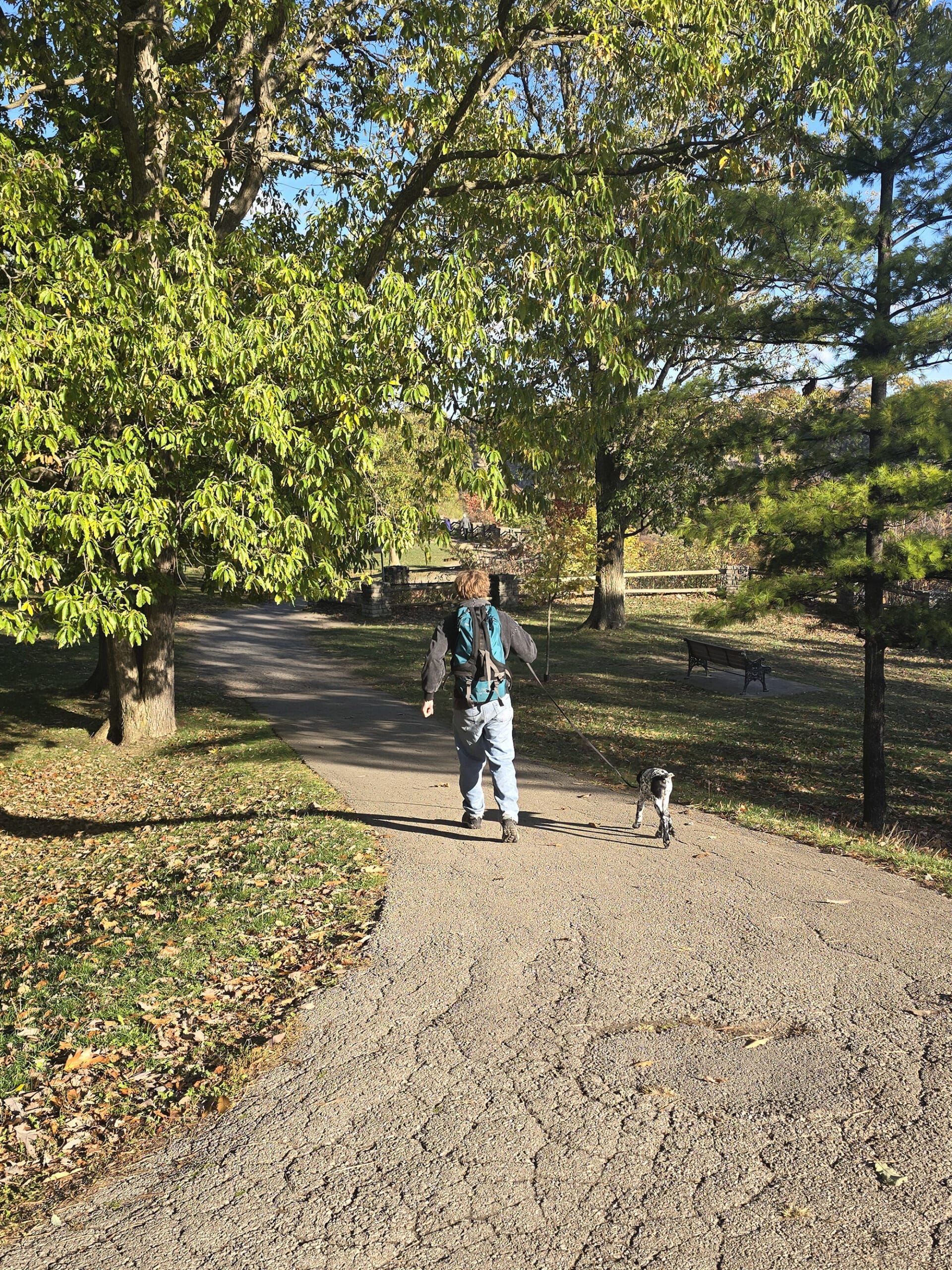
Day Use Area
Between the parking lot and the stairs that take you down to the trail system, there’s a large, sprawling area with dozes of picnic tables.
The are paths both through and along it, with one of those paths looking down over the trail system below, and - from more of a distance - the Niagara Gorge itself.
Aside from being a nice place to enjoy a quick picnic lunch, they’re also set up for more involved gatherings. I saw at least 2 BBQ grills, and there was also what appeared to be a picnic shelter.
That building was boarded up - I wonder if it’s open in the summer months?
Anyway, the nicest views along the fence were either to the right of the stairs - and behind the nature center - or far to the left.
The middle area has you looking down over trees below, but to either end of the park, it opens up to a water view.
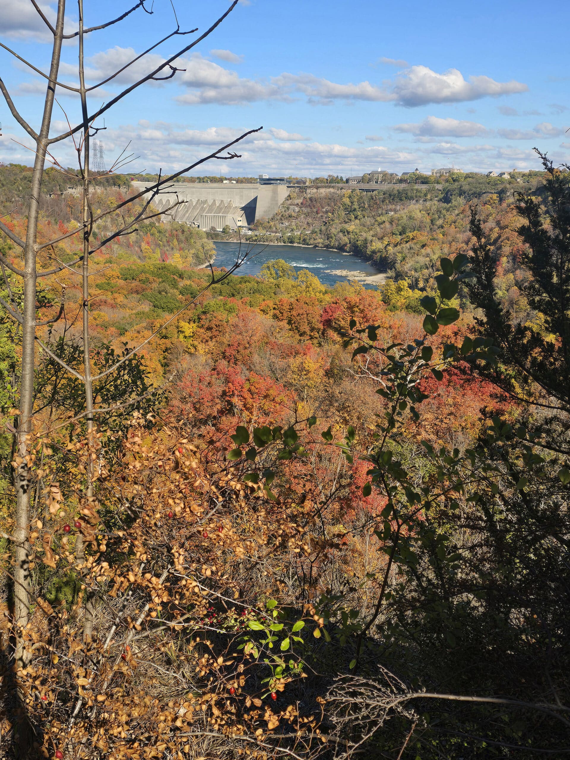
The view from the left side of the picnic area actually looks over what appears to be a dam, on the American side of the Niagara River.

Connectivity
Cell reception in the upper area - the picnic area/park, and around the Nature Centre - was great.
Due to my mobility limitations, we had split up and done two different sections of the Niagara Glen - I was hanging out in the street level areas, while he had gone down to the trails below.
We communicated from time to time, sending photos of what we were seeing, etc - and we both seemed to have pretty good connection.
That said ... at one point his MapMyRun run didn't seem to be broadcasting, even though it was still running for him. I wonder if he might have lost internet connection for a bit, even though we were able to talk on the phone at the time?
Share the Love!If you’ve made one of our recipes, be sure to take some pics of your handiwork! If you post it to Bluesky, be sure to tag us - @2NerdsInATruck, or you can tag us on TikTok, if you’re posting video. We're also on Pinterest, so you can save all your favourite recipes and park reviews to your own boards! Also, be sure to subscribe to our free email newsletter, so you never miss out on any of our nonsense. Well, the published nonsense, anyway! |
Entertainment and Activity
There is SO much you can do at Niagara Glen - here are some of the details.
Hiking
The hiking area is set up as one main loop trail, with several shorter offshoot and interconnected hiking trails along the way.
In general, you can expect the trails to be moderate difficulty, with some areas of easier, and some that are even more difficult.
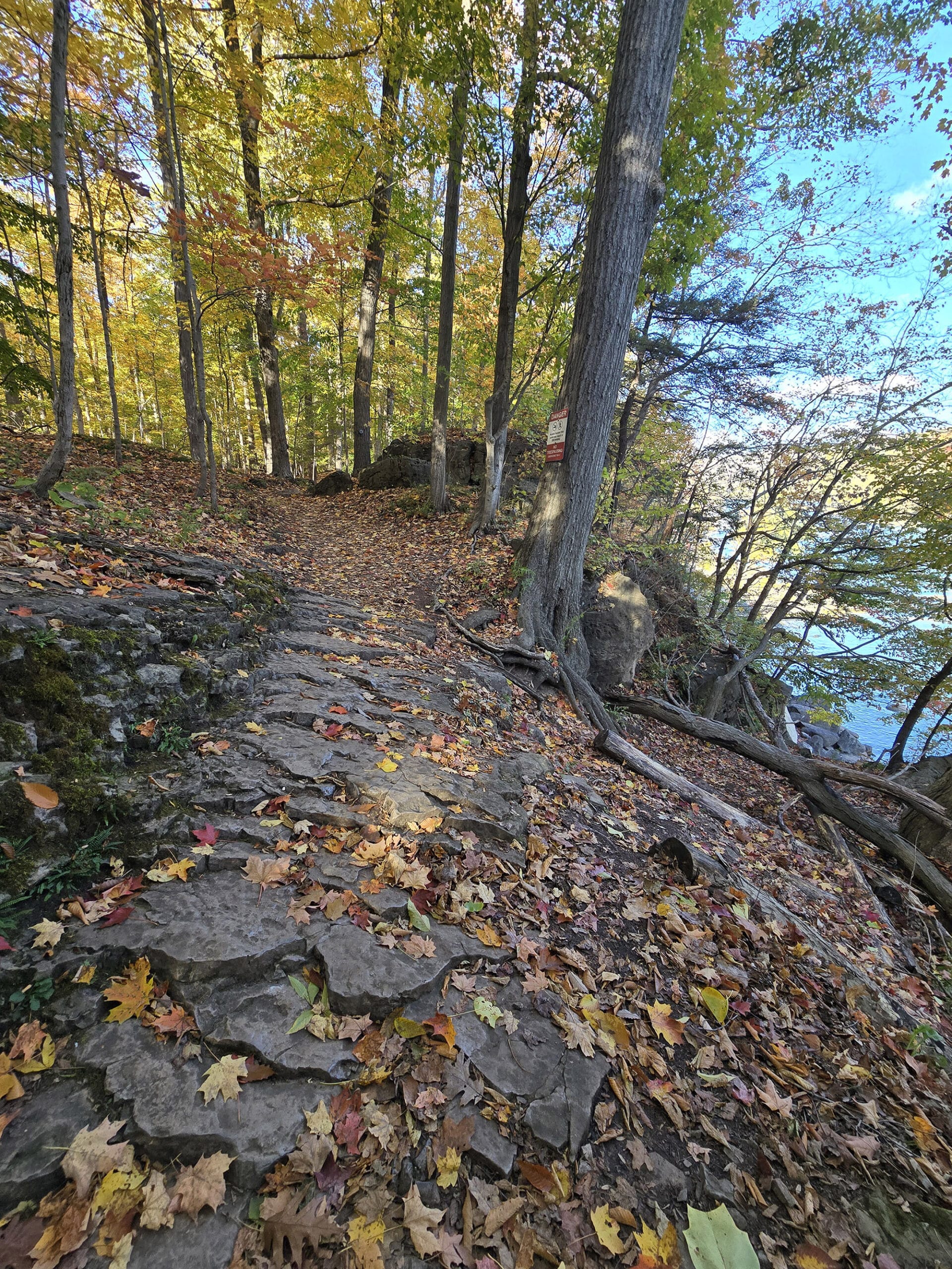
There are a lot of stairs, some steep sections, and uneven footing... pretty standard stuff for trails along the Niagara Escarpment, really. You’ll want to be sure to use proper footwear.
Porter did the trails by himself, here’s his insight about each of the trails:

Main Loop Trail (Blue) - 2.1 km / 1.3 mi
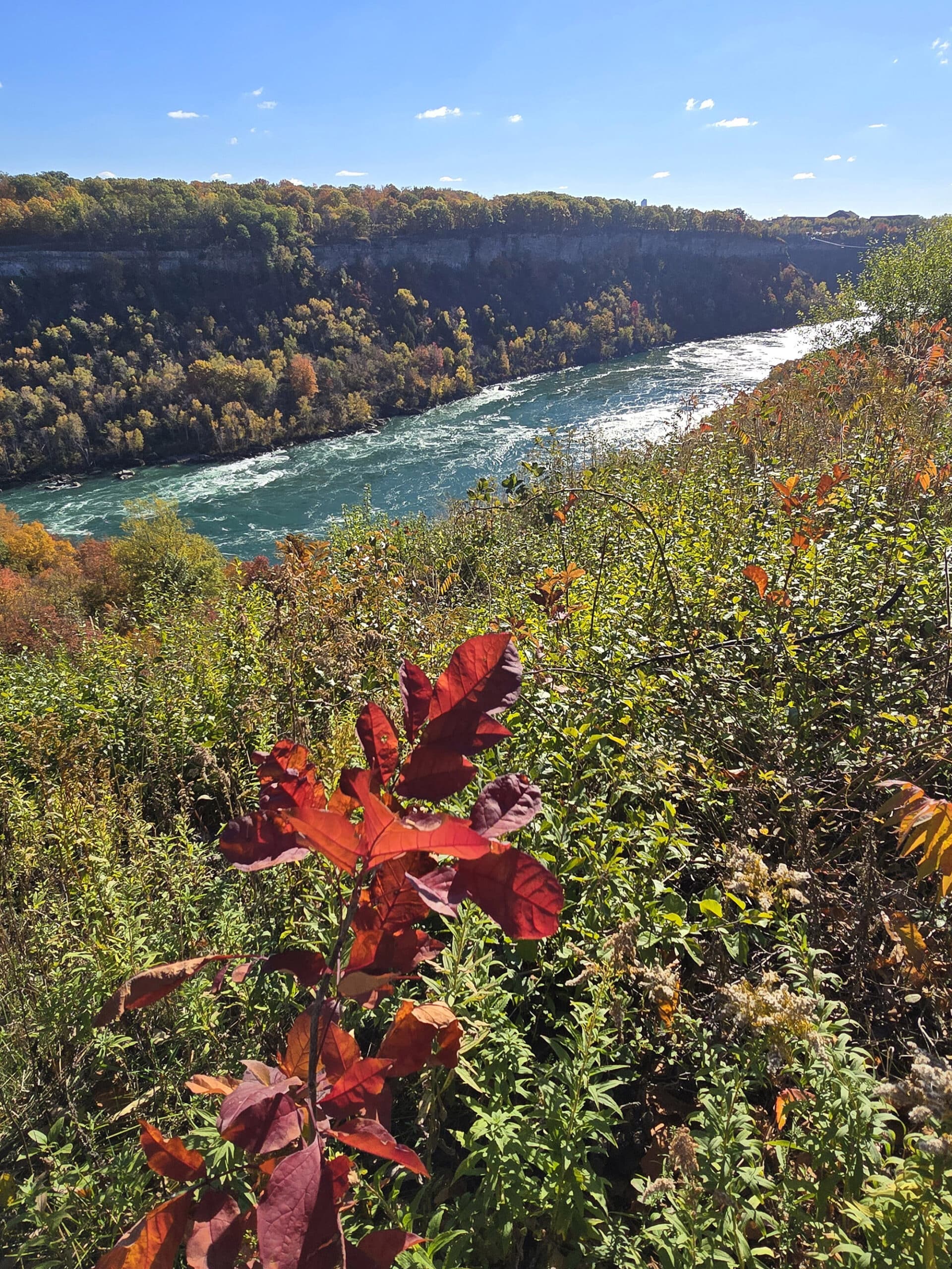
“The first staircase - that gets you down to the trail system - is 80 steps down, wide, sturdy metal stairs. At the bottom, it follows a fairly wide path along a steep cliff to your right, and fairly steep wooded cliff to your left.
The trailblazes are clear. There are lots of signs along the path warning you not to go hiking down the cliff and not to trespass.
The path overall is mostly flat other than the rocky steps/stairs.”

I'd give this trail a moderate rating due because of the amount of steps and you want to watch your feet a bit on the uneven trail with rocks and roots.
Where you follow along the river, there are small to medium-sized trees all along the river side of the trail, so even the outlooks are partially obscured.
That means the photos don't do justice, but there are some incredible views of the Niagara River and surrounding area.”

I hadn't even realized that I had been going downhill quite a bit over the span of the entire trail, it must have been very, very slowly.
Many amazing views along this trail!”

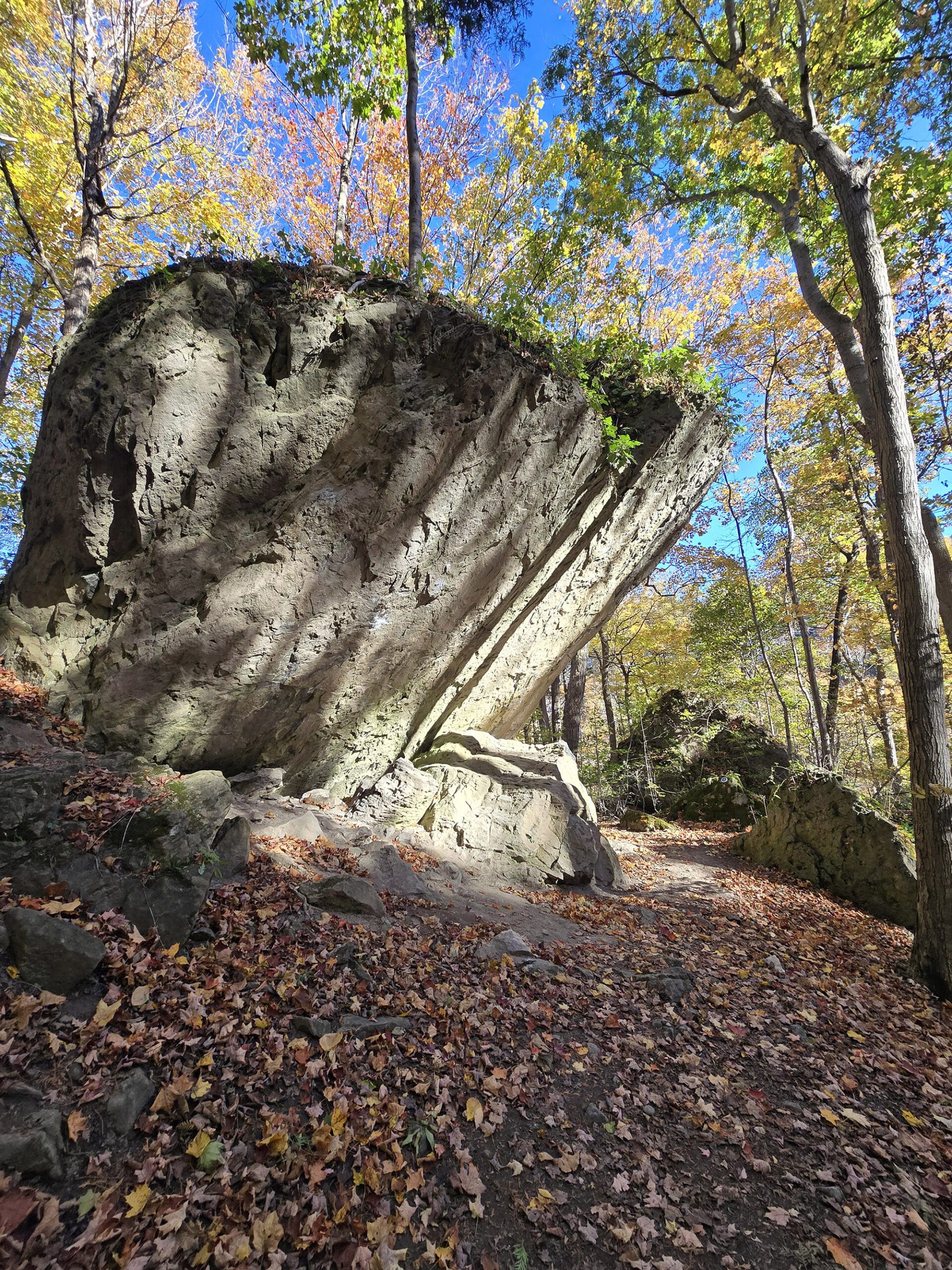
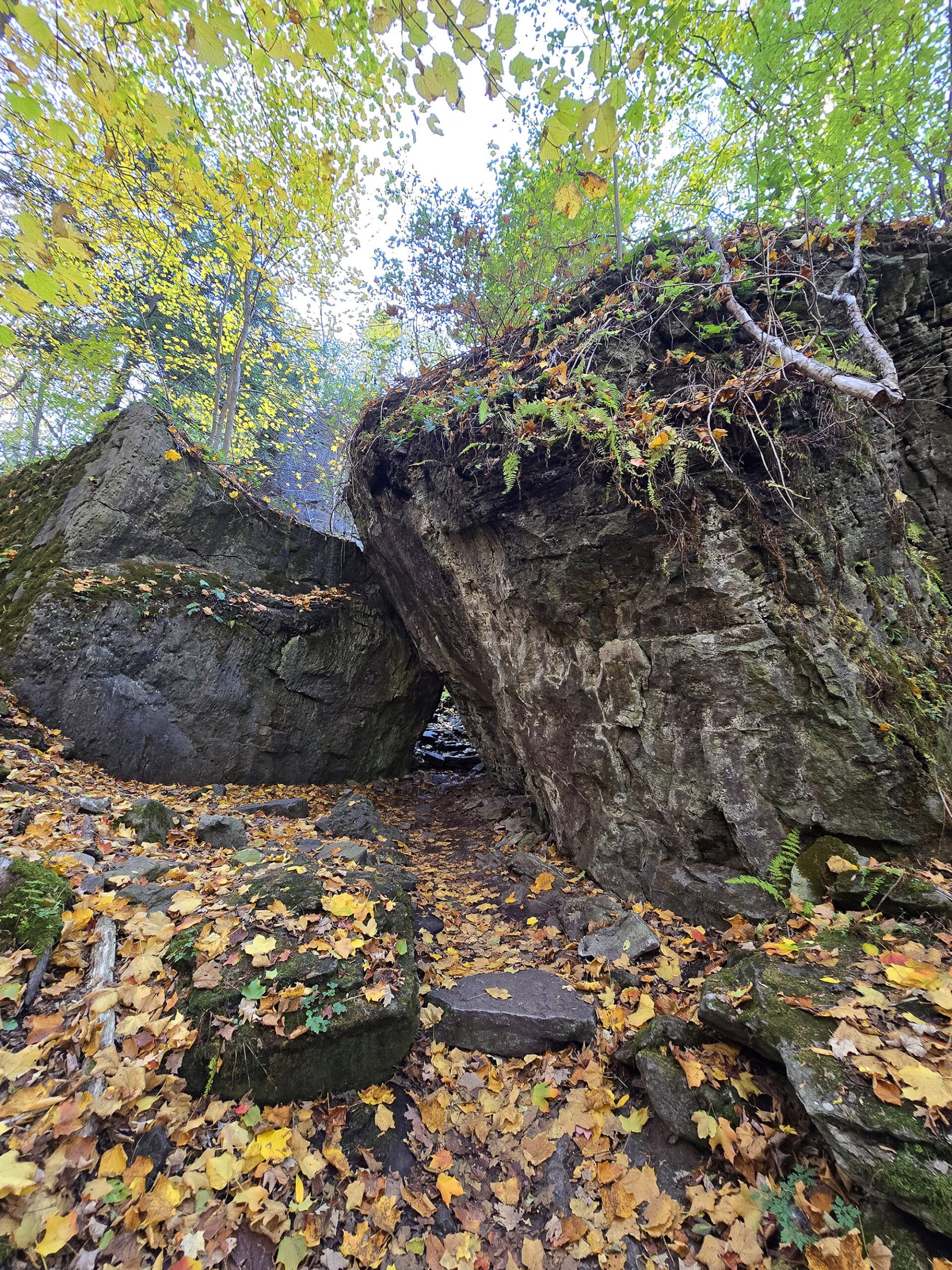
Bouldering Trail (Brown) - 220m / .14 mi
“The Bouldering Trail is a really fun little side path. It feels as if you've been given permission in this area to venture off trail because it's so different.
It just feels like you're playing. It is a little bit more into the moderate to difficult difficulty range with a little bit steeper areas and large rocky footing, but the views are absolutely amazing.
I loved walking past boulders along the path, they were amazing to look at.
I could also see where it would be a great place for rock climbing, if you had the right gear and training.”
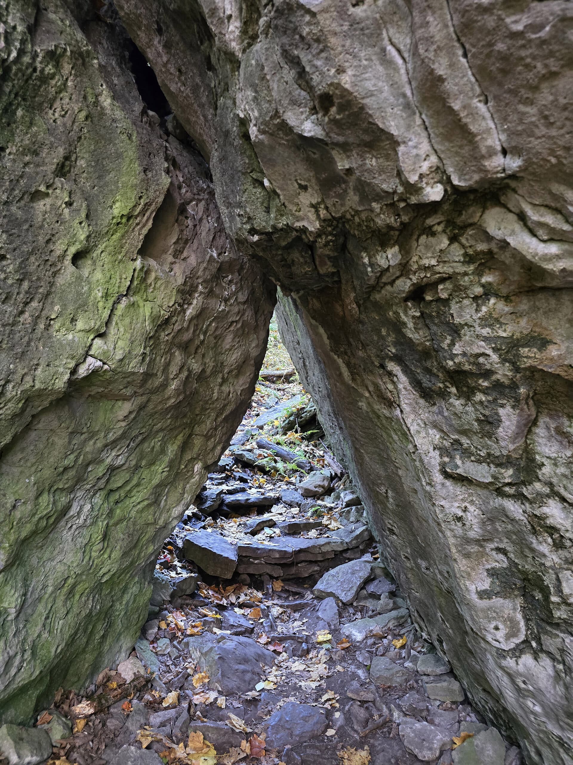
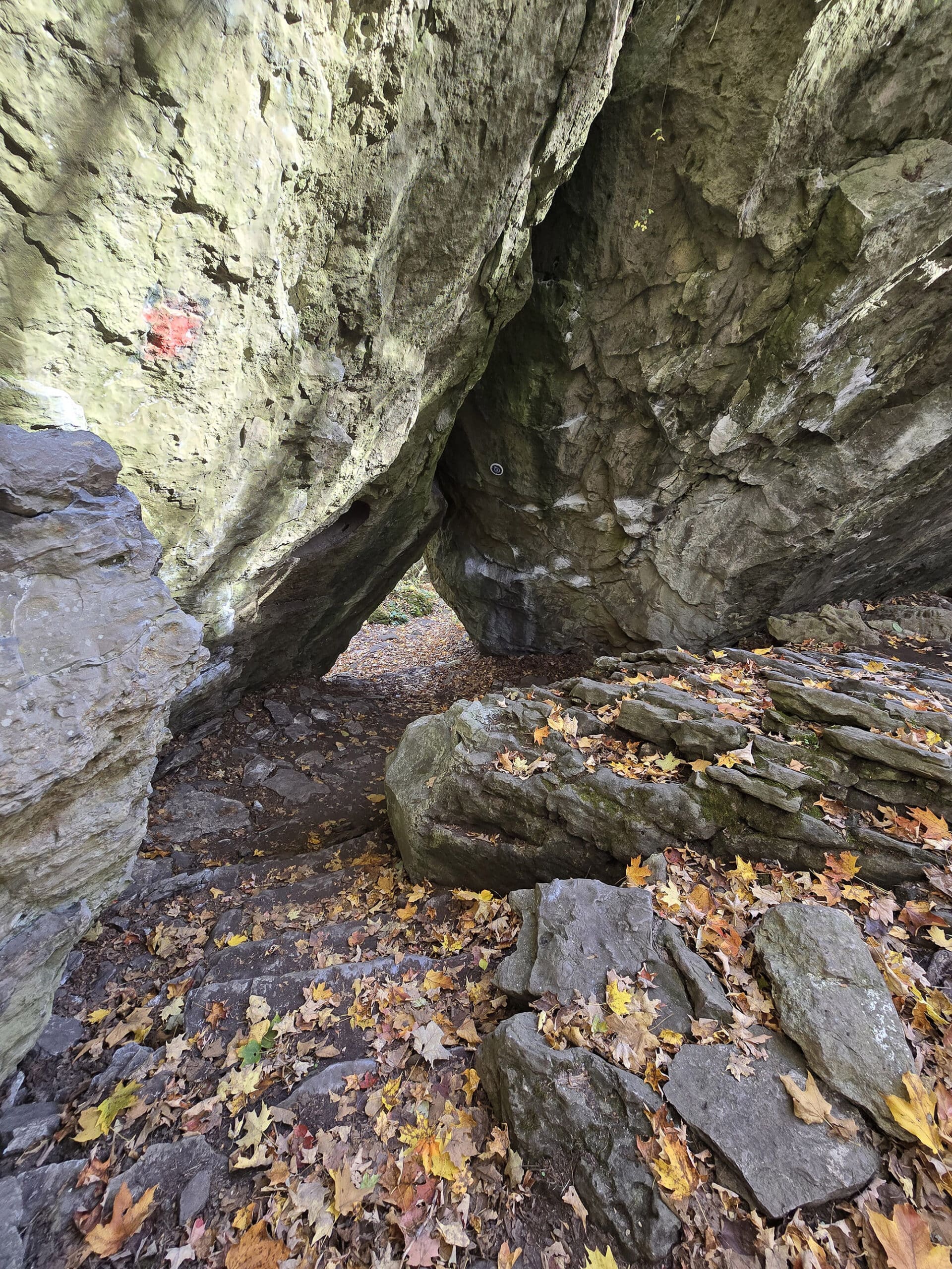
Cliffside Trail (Orange) - 310 m / .2 mi
“The Cliffside Trail has multiple large boulders on the sides. Little offshoots bring you to cliff's edge with amazing views as well.
Again, I rate this moderate difficulty due to the changes in elevation, but the main path is mostly pretty flat. The elevation changes are rocky steps, so it's on the easy end of being moderate.
Some of the blazes appear to be missing, but there are several blazes around.
There's a couple cases where clearly some people have made their own paths, but it's still pretty obvious where the main trail is in most areas.
The trail weaves around quite a bit, there were a couple of points where I kind of had to look around and try to find the trailblaze.
Some of the trailblazes have numbers, but I didn't know what they mean and I didn't see anything on the map to indicate the numbers.”

Cobblestone Trail (Red) - 216 m / .13 mi
Due to parts of the trail system being closed at the time of our visit, he did not do the Cobblestone Trail at all.
River Trail (Teal) - .42 km / .26 mi
“The River trail is a short, dead end offshoot trail that’s not quite as rocky as the rest of the trails - a bit easier to walk. You're just walking through a lovely forest right next to the Niagara River gorge.
It's a completely different vibe than the other trails I walked. I really liked it, and doesn't seem to be as popular.”

I really enjoyed it a lot and I'll definitely go back to this part of the trail next time I'm here.”

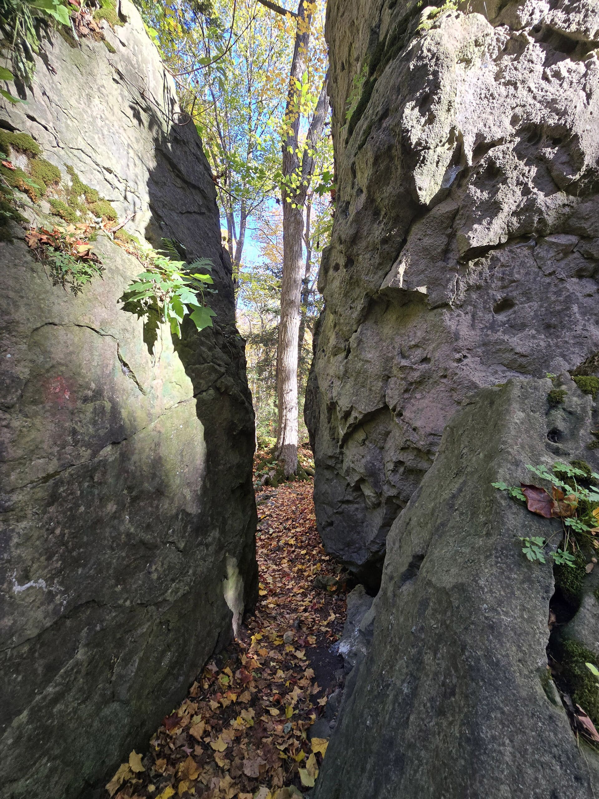
Terrace Trail (Navy Blue) - 400 m / .25 mi
“The Terrace trail picks up off the end of the Cliffside Trail, and it continues along these giant boulders.
There aren't as many of the rock stair steps here, but it is moderate due to some rocky unstable footing.
Some amazing views with moss-covered boulders, and the leaves falling everywhere when I visited in the fall, it was really beautiful to see.”

The rest of the Terrace trail was closed after that point, I was routed onto the Trillium Trail.”

Trillium Trail (Yellow) - 110 m / 0.7 mi
“For the Trillium Trail, you continue into this valley of boulders, moss-covered rocks with a path leading you through them.
The trail kind of winds around, and there are more trees in this area as well as more plants hanging off the rocks than in other areas.
This continues with the moderate rating due to a little bit of unsure footings from rocks on the trail. The short areas of inclines had nice natural rock staircases, kind of built-in, so it's definitely on the easier end of moderate.
Each trail junction is very well labeled. For the most part the trail is blazed well, but there are a couple of areas that could use another blaze.”

Woodland Trail (Green) - 240 m / .13 mi
Due to trail closures at the time of our visit, he did not do the Woodland Trail.
Whirlpool Trail (Purple) - 1.9 km / 1.18 mi
The Whirlpool Trail was closed at the time of our visit, which is too bad - I’m guessing there were some great views of the natural whirlpool, a little further up that trail!
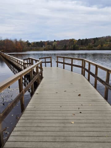
Niagara River Recreation Trail - 53 km
While Porter was down on the actual Niagara Glen trails, I happened across an unmarked trail, leading off from the south side of the parking lot.
It was a flat, paved trail that extended as far as I could see, and had some nice views of the gorge and the water below.
I Googled it after I got home, and learned that this was the Niagara River Recreation Trail. It extends for 53 kilometres, from Niagara-on-the-Lake to Fort Erie. Apparently it’s paved the whole way.
I didn’t notice it at the time, but the trail also crossed the road in front of the parking lot, where it continued north.
Anyway, while this isn’t technically part of the Niagara Glen trail system, it IS an accessible option for those who - like me at the time - can’t deal with the stairs, etc.

Points of Interest
There is a series of points of interest along the Niagara Glen trail system, which vary a bit depending on which map you’re looking at. These are:
(Old Map)
1 Wintergreen Cliff (Main Loop Trail)
2 Wilson Terrace Passage (Main Loop Trail)
3 Limestone Outcrop (Main Loop Trail)
4 Cripps Eddy (Whirlpool Trail / Main Loop Trail)
5 Balancing Rock (Main Loop Trail)
6 Rocks in the River (Main Loop Trail)
7 Natural Spring (Main Loop Trail)
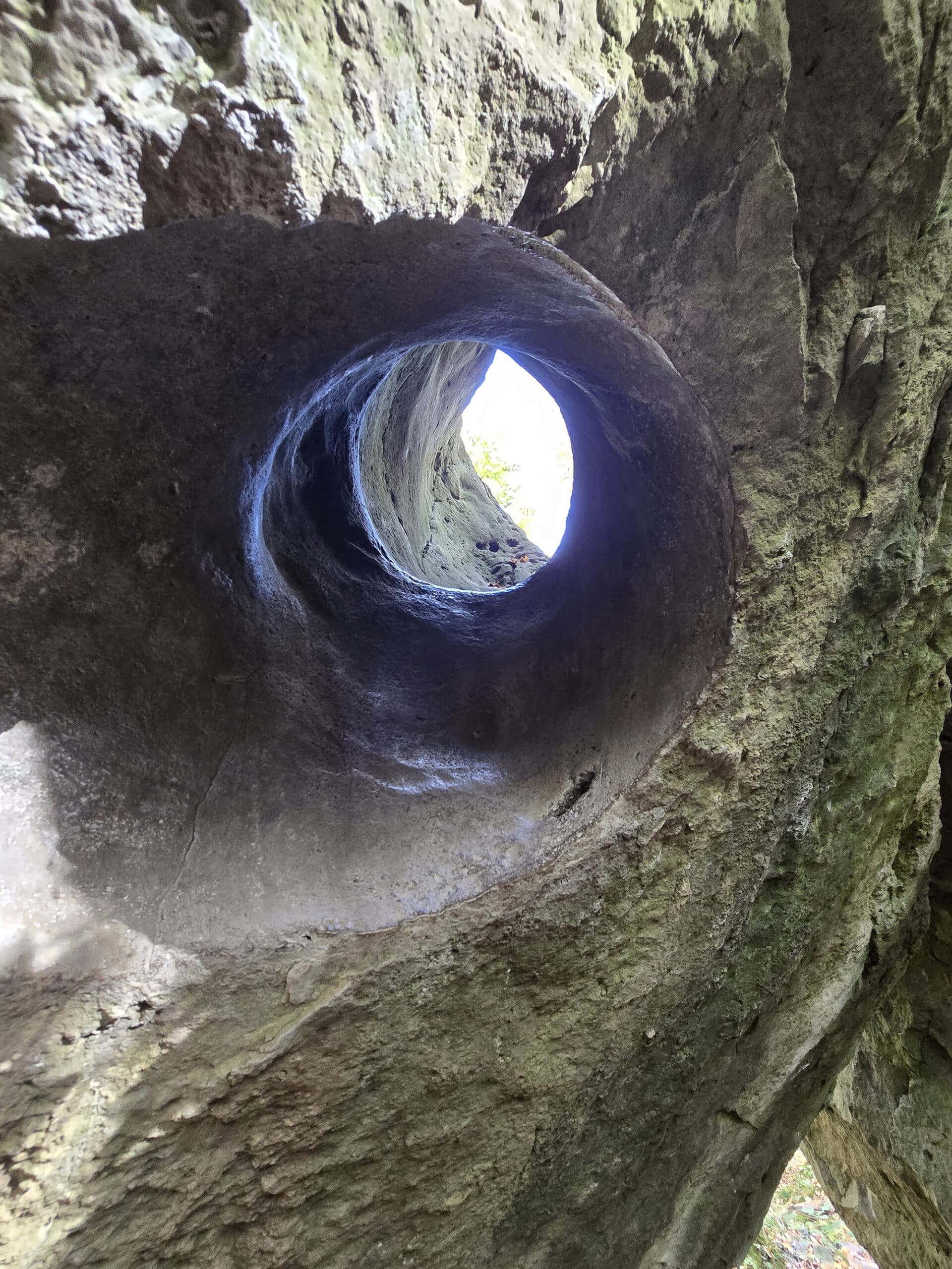
8 Mammoth Pothole (Cliffside Trail)
9 Leaning Rock(Cliffside Trail)
10 Boulder Wall (Cliffside Trail)
11 Devil's Arch (Cliffside Trail)
12 Face Carved in Stone (Picnic Area)
(New Map)
A Tulip Tree Stand (Main Loop Trail)
B Fossilized Reef (Main Loop Trail)
C Trilobites (Main Loop Trail)
D Wintergreen Bank (Picnic Area)
E Mammoth Pothole (Cliffside Trail)
Biking
Cycling is forbidden on the Niagara Glen Trails, but welcomed on the Niagara River Recreational Trail .
Also, as an FYI, there is a public bike repair station and bike racks near the Nature Centre, between the parking lot and the picnic area.

Bouldering
Apparently bouldering is a popular sport at Niagara Glen.
I had no idea that bouldering was historically looked at as a means of training for longer climbing routes... so that was a bit of knowledge I gleaned during our visit!
Anyway, if you want to engage in bouldering at Niagara Glen, you need a bouldering permit. Those are available both at the Niagara Glen Nature Centre, and at the nearby Butterfly Conservatory.

Birding, Wildlife, and Nature
As part of the Carolinian Life Zone, Niagara Glen is a great place to enjoy nature!
It’s known to have an impressive assortment of plant and animal species that call the area home, including several species at risk.
As we visited in the end of October, the bulk of wild flora we were looking at was more of the fall leaves variety, but I bet it’s gorgeous in the spring.
Interestingly, Porter didn’t have any luck with birding down on the trails AT ALL - but I saw lots of birds in the park area above the trail.
Of course, he was the one with the big camera, so I have no photos to share!
All told, I saw: American Robin, Bald Eagle, Blue Jay, Dark-Eyed Junco, and some sort of warbler I was unable to identify.
I was inside the Nature Centre and saw it through the window!
Boating
This is not an appropriate venue for boating, and the waters are known to be incredibly dangerous.
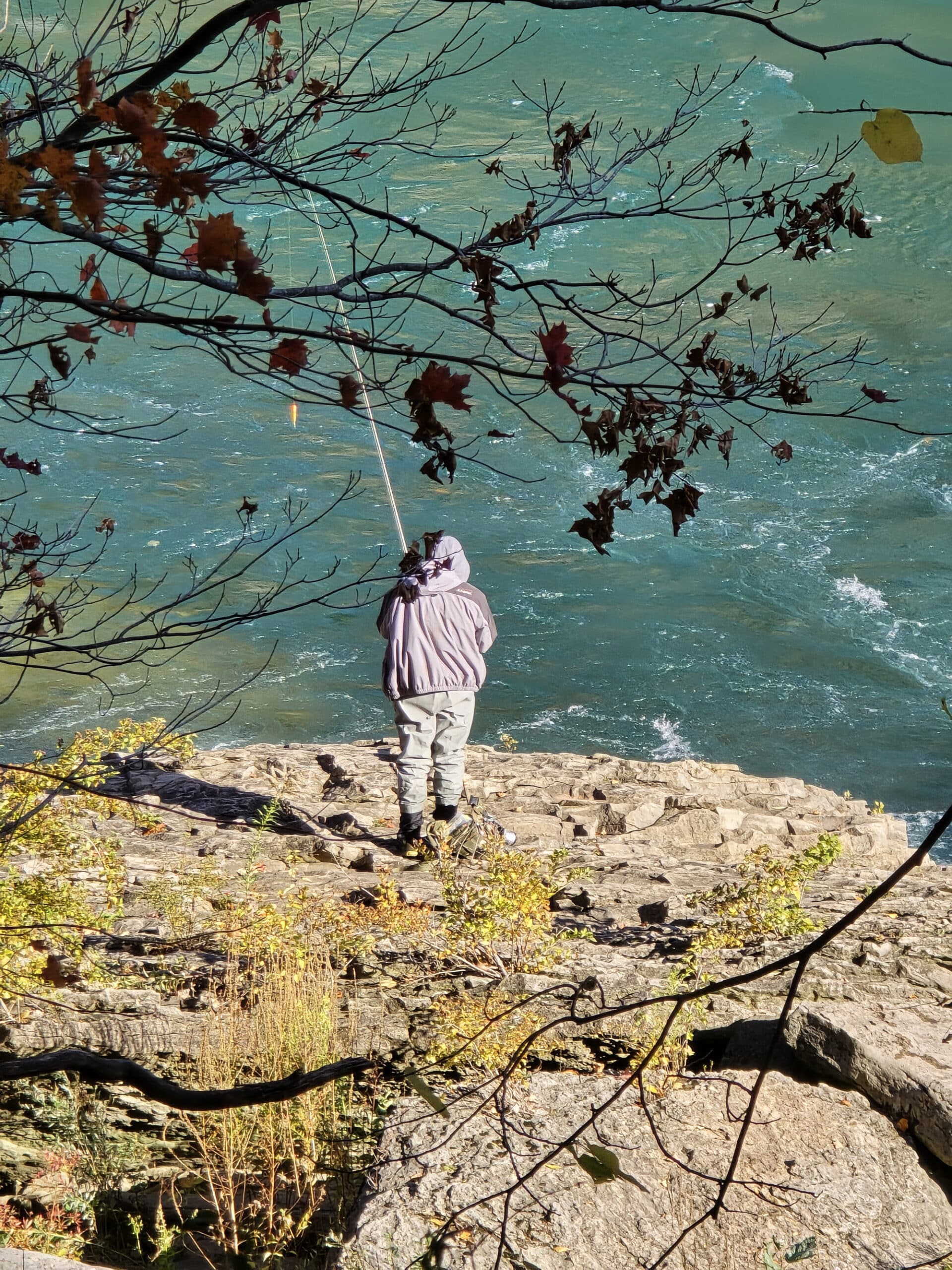
Fishing
Porter saw someone fishing down on the gorge, which surprised us both - so I looked it up.
Apparently the whirlpool is a REALLY popular fishing spot, with a huge variety of different species that you can catch:
Brown Trout, Carp, Catfish, Lake Trout, Muskie, Rainbow Trout, Salmon, Smallmouth Bass, Sturgeon, and Walleye... for starters.
It was an interesting rabbit hole to fall down into, wondering how that would work with the terrain and dangerous water conditions there.
If you’re interested in learning more, check out this post I found: Hooked On Niagara: How to Fish The Niagara Whirlpool - it’s an interesting post, and seems to be a great resource!
Educational Programming & Cultural Opportunities
Unlike a lot of the parks and such that we’ve been to, I didn’t see anything in the way of educational signs outside, beyond like... trail information.
So, the Nature Centre is definitely your best bet if you’re looking for a learning experience or two.
It was actually open at the time of our visit, so I went in - what a GEM of an attraction! They managed to fit so many cool things into a relatively small space.
I actually felt a little guilty wandering around what were essentially museum exhibits, without Porter, LOL.
Anyway, the park boasts that the carved rock formations of the Niagara Glen area represent “thousands” of years of geological history... while also referencing the Silurian period, which was over 400 million years ago.
Back to that museum type area... lots of cool things to see.
There was a touch table with different types of rocks and minerals, as well as a Nature Exchange Ethical Trading System. Which seemed like a cool idea.
Around the corner, there were shelving units full of different fossils, tables with animal pelts, and more.
Definitely be sure to check it out!

Misc
Niagara Glen is open during the winter months, sort of.
It looks like the Nature Centre isn’t open, but that you can access the trails - just be VERY careful if you do so.
We’re big fans of the crampons we bought a year or two ago - highly recommend getting a pair. It’s wild to walk across sheer ice like it’s not even there, and it definitely makes winter hiking a lot safer and easier!
Niantic Games
There are quite a few Niantic game stops in and around the parking lot and picnic area, with a few more out on the trail system.
That said, connectivity may or may not be an issue down on the trails.
Final Thoughts
HIGHLY recommend visiting - This was a gorgeous park area and the trails were epic. We could totally see why they were listed in whichever “Must-Do Ontario Hiking Trails” list I originally read about it in.
My only complaint is that there’s not a ton of info out there, and we did find a LOT of confusing, conflicting information before we went for the first time.
As an example, we’d read that it was 300 steps to get down to the trail system, which is why I noped out entirely. Getting down may not have been an issue, but I don’t trust my tendons enough to getting back up 300 steps after a hike!
As it turned out, it was only 80 - definitely more do-able!
Anyway, we’ll definitely be back!
More Southwest & Central Ontario Provincial Parks & Places to See
Want to read some more about the parks we've camped and at places we've seen in Southwestern & Central Ontario? Here are some more posts!
Southwest/Central Ontario Campground Reviews:
Awenda Provincial Park
Balsam Lake Provincial Park
Bass Lake Provincial Park
Bronte Creek Provincial Park
Bruce Peninsula National Park
Conestogo Lake Conservation Area
Craigleith Provincial Park
Darlington Provincial Park
Earl Rowe Provincial Park
Elora Gorge Conservation Area
Emily Provincial Park
Falls Reserve Conservation Area
Fifty Point Conservation Area
Inverhuron Provincial Park
Long Point Provincial Park
MacGregor Point Provincial Park
Mara Provincial Park
McRae Point Provincial Park
Meaford Memorial Park
Pinery Provincial Park
Point Farms Provincial Park
Port Burwell Provincial Park
Rock Point Provincial Park
Rondeau Provincial Park
Sauble Falls Provincial Park
Selkirk Provincial Park
Sibbald Point Provincial Park
Turkey Point Provincial Park
Valens Lake Conservation Area
Warsaw Caves Conservation Area
Wheatley Provincial Park
Southwest/Central Ontario Places to See:
Big Bay, Ontario
Canada's Dinosaur Park
Cheltenham Badlands
Devil's Monument
Doubes Trestle Bridge
Eugenia Falls Conservation Area
Flowerpot Island
Hogg's Falls
Inglis Falls Conservation Area
Indian Falls Conservation Area
Jones Falls
Keith McLean Conservation Lands
Lion's Head Lookout Trail
Mark S. Burnham Provincial Park
Menesetung Bridge
Mono Cliffs Provincial Park
Niagara Falls White Water Walk
Peterborough Lift Lock
Petroglyphs Provincial Park
Point Pelee National Park
Rattlesnake Point Conservation Area
Scenic Caves Nature Adventures
Spirit Rock Conservation Area
Springwater Provincial Park
Wasaga Beach Provincial Park
Want to explore beyond Southwest and Central Ontario? Check out our full list of Campground Reviews, Ontario Waterfalls, and other Places to See.
We also have a ton of Camping Recipes to cook up, while on your adventures!
Thanks for Reading!If you loved this post - or have any questions about it - please leave a comment below! We'd also love it if you would consider sharing the link on social media! |

Leave a Reply