
The Cheltenham Badlands are a series of rock formations with an otherworldly appearance, in Southern Ontario. Here’s what you need to know, if you’re planning to visit this unique landscape area!
Originally published on Marie Back On Ice: May 11, 2022. Updated and transferred here on 2/27/2025

Between being busy with settling in - then having to deal with a major disability - we didn’t get around to visiting until May of 2022.
I’d been enjoying a sudden bout of mobility, so we made the drive out to check out the Cheltenham Badlands trail, and the unique land formations.
As I mentioned in my original post:
“The badlands formation is an area of stunning red clay hills with faint green streaks.
It’s a unique landscape that is part of the Niagara Escarpment, an ecologically significant area in between the shores of several of the great lakes.
The Niagara escarpment is home to many conservation projects, several of which we’ve either visited or are planning to. There are a LOT of Ontario’s geological treasures in our surrounding area!”
It was the perfect time of year for it, too - cool enough for me to handle, early enough that there weren’t any crowds to deal with.
Still, we decided to plan for a weekday visit, to further minimize the potential crowds. We paid our reservation fee a few days before, and visited first thing in the morning.
What a great place! We had a fantastic walk and enjoyed the views immensely.
Anyway, after starting up this blog, we decided that a post about the Badlands fit a bit better here, as an interesting place to go visit.
It’s since changed hands - and some things have also changed in the process . So, here’s what we learned, saw, and experienced... but with some sections updated for the current situation!

The Basics:
Location Name: Cheltenham Badlands
Address: 1739 Olde Base Line Road, Inglewood, ON L7C 0K6
Website: Cheltenham Badlands - Heritage Trust
Price: $10-$20 for 90 minutes, $18-35 for a 3 hour visit. Price is per vehicle and does not include HST. *
Reservations: Cheltenham Badlands Reservations
Season: May 21 to November 20
* Visiting on foot or bicycle is free. There are bike racks, but there is NO roadside parking in the area. So, foot traffic is definitely more a thing for locals!
Logistics
The Cheltenham Badlands property is located in Southern Ontario, just north of Brampton. It’s in the Caledon region, on east side of Olde Base Line Road. Coming from 10 / Hurontario, it’s just past where the Chinguacousy Roads cross Olde Base Line rd.
It was just over an hour drive for us, coming from Hamilton - we left early enough to avoid rush hour traffic.
So, a bunch of policies and such have changed for Cheltenham Badlands in the last few years, as Credit Valley Conservation is no longer managing the property.

Registration and Check In
Due to capacity restrictions and limited spots, bookings are required to visit the badlands.
While registration used to be made via the Credit Valley Conservation website, the link has been moved to Cheltenham Badlands Reservations.
Admission fees are $10 per 90 minute booking if you go Monday-Thursday, or $20 if you’re going Friday-Sunday, or on a holiday. (Plus HST, of course!). They now offer three-hour bookings, those are $18-35, depending on what day you go.
They do not accept cash or cards at the property, so even going there without a reservation means you’ll have to hope for enough cell reception to access the booking website from the parking lot.
They still allow for changes to your reservation, which can be done via a link in your confirmation email. You aren’t able to make any changes to - or geta refund for - you booking within 48 hours of your booking, though.
If you notice a mistake in your reservation that could affect you either getting your confirmation, or getting in (typo on the license plate number), you can email them at email badlands@heritagetrust.on.ca to sort it out.
When you get to the gate, you can scan your QR code or enter a pin, when it doesn’t recognize your car.
Parking Restrictions
Before you book your spot, there are some things to know about limitations.
First, you can only book a spot for a regular sized passenger vehicle. Due to the nature of the parking lot, they do not allow buses, RVs, or trailers.
You CAN park a motorcycle there, but the check in process is a little different. Because the gate reader can’t “see” the license plates on motorcycles, you need to be sure to have the QR code or pin code on you, as you arrive.
Parking Reciprocity
When management of the Cheltenham Badlands property changed hands, there were some changes to reciprocity with other parks.
So, you can no longer use the Credit Valley Conservation or Toronto and Region Conservation Authority to cover your visit to the Badlands.
Also, reserving a parking spot in the Cheltenham parking lot no longer gives you access to the nearby conservation areas (Island Lake Conservation Area or Terra Cotta Conservation Area) that it used to.
Maps and Signage
We haven’t been to Cheltenham since the change of ownership, so we’re not sure what the current map and signage situation is.
We’ll be visiting when the season opens later this year, but here’s a trail map from before the change. I don’t expect the trails themselves would have changed much.

Washrooms
There were several Port-a-potties in the parking lot, and they seemed well maintained, at the time. We didn’t see more any along the trails or at the viewing platform.
The new Cheltenham Badlands website mentions there being washrooms on site - we’re assuming they’ve changed from what we saw on our last trip - so I’ll be updating this next time we’re out there.
Connectivity
We had pretty spotty cellular reception the last time we were out there, on Rogers Wireless.
Accessibility
If you use a wheelchair, the accessible boardwalk is basically all you’re going to be able to access. It’s about 15 metres from the accessible parking spot, which is up the road from the main lot.
For those who have hampered mobility and do not require a wheelchair (crutches, boot, etc), you can probably walk from the main parking lot to the viewing platform.
If you have any mobility concerns, I wouldn’t recommend walking the longer trail. There are steep areas, narrow areas, very rough areas, and just weird angles to walk. There aren’t really any spots suitable for sitting down.
If I’d still been in a boot, I definitely would have hurt myself trying to navigate that trail.
If you need the accessible parking space, they’ve now got a weird set up for that. You used to be able to book accessible parking specifically.
Now, you book a regular spot, show up, and talk to the person on duty -who’s apparently parked in the accessible spot. They go and move their car, and you drive up and around to take that spot.
I guess you just have to hope you’re the only one who needs the spot, at the time you’re there? Just a really odd set up.

Pets
Dogs are allowed, but need to be leashed and picked up after.
Parking
There is a smallish parking lot at the main gate, and a single accessible parking spot at the gate outside of the viewing platform, just up the road.
The booking fee also serves as a parking fee, and buys you 1.5 hours. (They now have an option for a 3 hours maximum booking, though they limit the numbers of visitors who can book it that long).
The 90 minute parking restrictions definitely allow enough time if you’re just going to the viewing platform, but is a bit rushed if you do the trail as well.
If it’s not your first time there, or you hike *with purpose*, it should be enough time. It just felt rushed trying to enjoy the scenery our first time there, with the clock ticking.

Miscellaneous
They do not allow drones on Cheltenham Badlands property, and are longer issuing special use permits for things like events, group booking, or professional photography sessions.
Also good to note: when the trail gets wet and slippery, it’s closed for public use as a safety measure.
In this case, they’ll have you walk up the sidewalk along the main road, to go directly to the viewing platform boardwalk area.
Personally, I’d just re-book the date and time if it’s been rainy.

Share the Love!If you’ve made one of our recipes, be sure to take some pics of your handiwork! If you post it to Bluesky, be sure to tag us - @2NerdsInATruck, or you can tag us on TikTok, if you’re posting video. We're also on Pinterest, so you can save all your favourite recipes and park reviews to your own boards! Also, be sure to subscribe to our free email newsletter, so you never miss out on any of our nonsense. Well, the published nonsense, anyway! |
Cheltenham Badlands History
The Cheltenham Badlands is a property owned by the Ontario Heritage Trust, involving a couple of hiking trails, and a boardwalk / viewing platform overlooking the unique ridge formations of soft shale in the “badlands” area.
It’s one of the most popular and recognizable natural heritage landmarks in the area, and one of the best examples of the importance of conservation work, IMHO.
The history of the area has been traced back to the ancestors of the Mississaugas of the Credit, who hunted, fished, and farmed in the area over many generations.
European settlers developed the land, and by the early 1900s it was being used as productive farmlands. There were several crops - including an apple orchard.
Poor farming practices and the removal of trees led to erosion of the soil cover, exposing the underlying shale.
The formations that we see today are the result of not only that erosion of the shallow topsoil, but also the effects of the conditions the shale was then exposed to.
Years of rain, snow, ice, and resulting thaw conditions have all contributed to erosion of the shale, forming the visually stunning appearance the area is known for.

Entertainment and Activity
Hiking
There are 3 trails on the Cheltenham Badlands property:
Boardwalk - 0.6 km
Badlands trail - 0.32 km
Bruce Trail 1.33 km
It’s kind of a y shaped set up. You walk the badlands trail from the parking lot, it’s just a short walk to the trail divide.
If you go to the left, it’s a 1.33 km section of the Bruce trail, ending at Creditview Rd.
Going to the right, it’s just a short walk to the badlands viewing area.
The Badlands Trail - 0.32 km/1,050 feet
Not much to say about this trail, it’s definitely what I would consider a “connecting trail”.
I guess it literally connects a section of the Bruce Trail to the viewing platform area, so... that tracks.
Anyway, fairly basic walk through some young forest, with sections of shrubs and wildflowers at the time of our visit.

The Bruce Trail - 1.33 km/1,455 yards
I was feeling pretty cocky about my ability to walk at this point, so I totally believed the employee when she said it was an easy walk.
It... really wasn’t!
Yes, my feet are still a bit weak and wonky from 2 years of dealing with fluoroquinolone toxicity, but to be fair ... even my runner husband said that it was fairly challenging.
There were some very steep sections, and a lot of very uneven ground.
It was a really pretty walk though.
We got to the end of the trail section - at Creditview rd - and turned around, heading back to the trail divide and on to the viewing area.
I suppose you could probably keep going on the Bruce trail from Creditview rd, but we didn’t bother crossing the street, so I’m not sure how / if it continues from there. So, we treated it as a there-and-back trail.

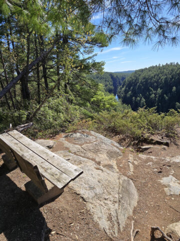
The Boardwalk and Viewing Platform - 60 metres/197 feet
After making it back to the trail split, it was just a short walk to the viewing platform area, and it was a gorgeous view!
My photos in no way do justice to the reddish hue of the Queenston shale, or the narrow greenish bands all over the red rock. I think they look kind of white in my photos - that’s actually green iron oxide you’re seeing in the light stripes!
The red is iron oxide as well, the green areas are areas that show the change of red iron oxide to green, due to circulating groundwater.
This whole area of soft rock was formed at the base of an ancient sea, hundreds of millions of years ago. How cool is it, that we can see this, today?
On one hand, I’m glad it’s been preserved - sounds like people were destroying it. I don’t doubt it!
On the other, a friend of mine mentioned that she had wanted to go there to take cosplay photos in her Star Trek original series costumes, and... man, that would have been amazing!

Birding, Wildlife, and Nature
We were kept company by a LOT of blue jays! There was one particular section of the trail - early on - where we saw at least a dozen of them.
I usually feel lucky to see *A* blue jay when I’m out and about!
They were all screaming at each other for that section, even when we couldn’t see them.
Beyond the Blue Jays, we also saw deer tracks, and a Black Swallowtail Butterfly.

Niantic Games
There are 4 Portals / Pokestops / Gyms / etc at the park - one in the parking lot, 2 in the area of the badlands themselves, and one along the trail.
You may or may not have enough cell reception to play, but really... you’re going to be there less than 3 hours!

Final Thoughts
The Badlands themselves are definitely the *draw* here. The other hiking is nice enough, but nothing to really write home about.
The badlands area though, is really cool. It feels otherworldly, like you’re looking out over Mars or something.
Kinda sad that we didn’t get to visit it before it got popular - and the badlands themselves were gated off from public access - but we totally understand why it’s the case.
Still - imagine walking through those dunes! I bet it was amazing, back in the day.
Anyway, this is definitely somewhere that everyone should see once, if they’re within a reasonable drive of the area. I don’t know that I’d drive several hours out of the way to see it - or for the hiking - but it’s a cool natural attraction nonetheless.

More Places to See
Looking for some nice sights to see and great places to visit while you're out on your camping adventures? Here are a few of our favourite day use parks, attractions, etc.
Aguasabon Falls & Gorge
Amethyst Mine Panorama
Batchawana Bay
Big Bay, Ontario
Big Chute Marine Railway
Bruce Peninsula National Park
Canada's Dinosaur Park
Chippewa Falls
Devil's Monument, Bruce Peninsula
Falls Reserve Conservation Area
Fielding Bird Sanctuary
Flowerpot Island
French River Provincial Park
Gariepy Creek Falls
Hardy Lake Provincial Park
Healey Falls
Inglis Falls Conservation Area
Keith McLean Conservation Lands
Menesetung Bridge
Mink Creek Falls
Old Woman Bay
Onaping Falls
Ouimet Canyon Provincial Park
Petroglyphs Provincial Park
Point Pelee National Park
Provoking Falls
Rattlesnake Point Conservation Area
Sand River Falls
Scenic Caves Nature Adventures
Scenic High Falls
Screaming Heads
Spirit Rock Conservation Area
Temagami Fire Tower
Terrace Bay Beach

Thanks for Reading!If you loved this post - or have any questions about it - please leave a comment below! We'd also love it if you would consider sharing the link on social media! |


Leave a Reply