
When visiting Bruce Peninsula National Park, nearby Devil's Monument is a popular attraction to see. Here's everything you need to know, to visit this geological marvel!

It’s something I’d been looking forward to seeing for a WHILE.
Devil’s Monument is one of the most popular destinations along the Bruce Trail - it’s the only complete flowerpot on the east side of the Bruce Peninsula. Apparently it’s also the largest one on Bruce Peninsula. (There are some big ones out on Flowerpot Island, of course!)
Anyway, given that it’s on the Bruce Trail, I’d been hesitant to visit - those hiking trails can get pretty hardcore!
I was having a pretty good mobility day, and hey... several reviews mentioned the trail being easy, so we decided to give it a go.
There’s not a ton of information out there about actually getting to the area, so with all of the references to “the” parking lot, we assumed that the one Google Maps took us to was *it*.
This was not the case.
We ended up having to decide between two trails, picked the shorter one “to be easy on me”... and, uh... that was certainly a choice.
Anyway, there’s a short and easy way to get there, a long and easy way to get there, and a long an VERY difficult way to get there.
Now that we know the difference between those options, let us share that knowledge with you, so you can make a more education decision than we did!
Anyway, lots to talk about, so let’s get to it!

The Basics:
Location Name: Devil’s Monument
Address: Northern Bruce Peninsula, ON N0H 1W0 (Click for Google Maps Location)
Website: Ontario Heritage Trust - Devil's Monument
Price Free!
Reservations: Not applicable
Season: Open year-round.
Logistics
Some information to help you plan your visit to Devil’s Monument:
Registration and Check In
This is a very informal attraction to visit, there’s no registration or check in required. Just go to your choice of parking lot, and walk in!
Parking
As I mentioned, there are actually two parking lots, and neither of them are really easy to find online:
Lillie Family Parking Area
We chose the one closest to Bruce Peninsula National Park - coming at the area from the North.
It’s about 27 minutes from the Cyprus Lake Campground, accessed by turning off the main highway at Dyer’s Bay Rd, and continuing on to Britain Lake rd.
The coordinates are APPROXIMATELY 45°08'50.0"N 81°20'21.0"W - click for the Google Map location.
As you're driving in from Dyer's Bay road, the parking lot will be on your right, and it's pretty obvious - enough space for maybe 3-4 cars, with some trail signage.
From there, you can either cross the road to get to the Bruce Trail, or turn right on the road and walk down it as part of the Minhinnick Side trail, which veers off the road when the road ends.
This parking lot is about 1.5 km from Devil’s Monument, via either of the 2 trail options mentioned - more on the trails in a bit, though!

Borchardt Road Parking
The other option comes at the attraction from the south - about a 42 minute drive from the Cyprus Lake campground.
We only learned about this one because we were shocked to see a couple with a baby at the lookout - and could not IMAGINE carrying a baby over the path we’d just taken.
It’s located and/near 163 Borchardt Rd, Northern Bruce Peninsula, ON N0H 1W0 (click for the Google Maps location).
It sounds like this is a larger parking lot, and may or may not be paid parking - only reviews complain about parking, though the couple said it hadn’t been a pay lot.
Maybe there’s a seasonality issue, maybe it has something to do with all the reviews that mention the pay machine not working... I don’t know. Something to keep in mind!
Anyway, this option also has two potential routes in - Bruce Trail (690 m), or Minhinnick Side Trail onto the Devil’s Monument Side Trail (780m).

Maps and Signage
Some info to help you get around the Devil’s Monument Area:
Maps
While I had a devil of a time (HAH!) Trying to figure out how to get to the area, there are actually some really nice maps in place, in the parking lot we used, and at Devil’s Monument itself.
Here’s a zoomed in version, of the actual area involved:

Signage
Bruce Trail Conservancy generally does a fantastic job of marking the trail, and this part of the Bruce Trail (main trail) and the various side trails involved are no exception.
There were signs right from the parking lot directing us to the two trail options, trail signs had some details about the trails, and there was the usual signage telling you how to read the trail blazes.
In terms of the blazes themselves, we found them to be clear, bright, and high contrast - easy to see! - and well placed along the trail.
At no point did we feel at all lost, it was easy to follow the trail.

Connectivity
We didn’t look at our phones option, but when we did - usually to check trail / fitness apps, etc - we didn’t seem to have any real issues on Rogers Wireless.
Take that with a grain of salt though - there are a bunch of reviews out there that mention there being no cell service.
Pets
Dogs are allowed, but are supposed to be leashed at all times, and picked up after. We didn’t notice any garbage cans along the way, so plan accordingly.
Additionally, you’re definitely going to want to consider your dog’s size and physical ability, as well as YOUR ability to carry it.
The Minhinnick Side Trail should be easy for almost any dog, but the Bruce Trail is DEFINITELY more demanding.
When you get to the actual Devil’s Monument flowerpot, there are two sets of stairs - a narrow, kind of sketchy, metal set, then a series of wooden stairs with the platform.
If you want to go below the deck area to the base of the flower pot, there are some steep areas to scramble down, rocks to jump down over, etc.
You might find yourself having to carry a smaller dog.

Washrooms
There are no washrooms at the Lillie Family parking area or on any of the trails. While you should definitely bring water with you, I wouldn’t advise showing up with a full bladder!
Accessibility
I wouldn’t call any of this area wheelchair accessible, and you’re definitely going to want to avoid the Bruce Trail sections if you’ve got mobility issues.
You can get *A* view of the flowerpot from up top, but if you want a good look, you’ll need to go down some stairs.
Park Store /Visitor Centre
There’s no gift shop, visitor center, or anything of the sort at Devil’s Monument.
Day Use Area
There’s not really what we’d consider a day use area - ie: a picnic area.
That said, there are a couple benches in the area of the flower pot itself - a more rustic one at the top, right off the trail, overlooking the flowerpot... and a second one down on the wooden decking area below.

About Devil’s Monument
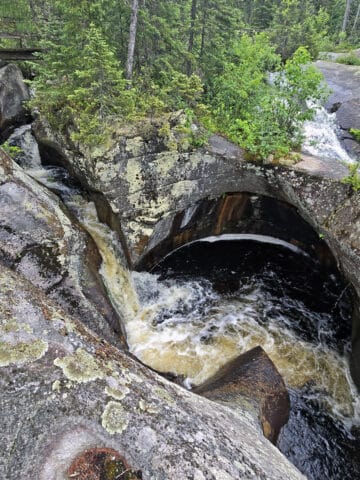
Devil’s Monument is a geological feature known as a flowerpot.
Like the flowerpots on Flowerpot Island, it was formed over 5000 years ago, by the passing of glacial Lake Nipissing.
The dolomite that the flowerpot is made of actually started forming long before that - 440 million years ago - as the buildup of skeletal remains of marine animals, on the bottom of an ancient lake.
Anyway, over time, that sedimentary rock formed into large masses, which were eventually eroded by the receding glacier. Softer stone was worn away, leaving the flowerpot formations behind.

Signage near the flowerpot tells us that it reaches almost to the brow of the escarpment, which is definitely impressive - especially considering it’s the only complete flower pot on that whole side of the peninsula.
So, it’s a survivor!
These days, the Ontario Heritage Trust owns / manages the property that Devil’s Monument resides on - formerly the location of the LeFeuvre-Chupac, Minhinick, and Schneider properties.
There are a couple main levels of viewing platform, starting right at the trail with a rustic, rocky overlook spot - shown above.
From there, you can take a metal staircase down to the wooden platforms below, for a much better view of Devil’s Monument.

Just note: You won’t be able to get TOO close to the base - there are signs designating it as a restricted area, and asking visitors to stay on the blazed trails.

Share the Love!If you’ve made one of our recipes, be sure to take some pics of your handiwork! If you post it to Bluesky, be sure to tag us - @2NerdsInATruck, or you can tag us on TikTok, if you’re posting video. We're also on Pinterest, so you can save all your favourite recipes and park reviews to your own boards! Also, be sure to subscribe to our free email newsletter, so you never miss out on any of our nonsense. Well, the published nonsense, anyway! |
Entertainment and Activity
Beyond seeing the Devil’s Monument flowerpot itself, there are several things you can do while visiting the area. Here’s what you’ll need to know about your options.
Hiking
So, as I’ve mentioned... there’s an easy way to get to Devil’s Monument, and there’s a hard way.
The trail you choose to get from your choice of parking lot to the main attraction will DEFINITELY have an impact on your experience. Here are your options:

Bruce Trail (Main Trail)
You can access the Bruce Trail from either parking lot, our experience with it is the north section of this portion of the trail (Between the Lillie Family Parking Lot and the Devil’s Monument).
I would expect the southern section to be similar, though.
Anyway, heading out from our parking lot, the first section of trail was easy - the first photo of the photo above.
Things quickly got out of hand!
This is a very difficult trail - steep inclines, boulders, big roots and trees to climb over, etc.
By maybe 400 metres in, I was seriously doubting my ability to continue... while ALSO seriously doubting my ability to go back the way I came. It was definitely anxiety-inducing, given my mobility issues. Honestly thought I was going to get stuck out on the trail!

If you choose this route, you’ll be treated to amazing views of Georgian Bay and the surrounding landscape.
If my tendons weren’t an issue, I would absolutely choose this trail over the alternatives.
Anyway, this trail is about 1.5 km from the north parking lot to the monument, or 690 meters from the south parking lot.

Minhinnick Side Trail
While it’s a part of the Bruce Trail system, the Minhinnick Side trail is *nothing*like the Bruce Trail in this area.
I was incredibly thankful to have this option pointed out to me by a couple when we reached the viewing platform - there was absolutely no way I was going to be able to go back along the Bruce Trail, it damn near killed me on the way in!
The Minhinnick Trail is wide, flat, well packed, with only the odd small root or whatever as obstacles. An easy walk in the woods!
When coming from the north, as we did, the section of the trial just before the parking lot is actually roadway - very little traffic, though.
To get from that parking lot to the monument - along the Minhinnick Trail - is about 1.5 km.
To get from the other parking lot to Devil’s Monument is less than 800 metres. We didn’t do that section of the trail, but the couple we met did - they said it was flat and easy.

Lillie Family Side Trail / Lillie Pothole Side Trail
While these trail sections aren’t directly on the path between the north parking lot and the monument area, they’re worth checking out if you’re coming in from that north parking lot.
The Lillie Family Side Trail is a short - 260 m - section of trail that connects the Bruce Trail to the roadway section of the Minhinnick Side Trail.
One end of it starts just over 200 metres from the Bruce Trail access point (across the street from that parking lot), and the other is less than 300 metres down the road from the parking lot.
Had I known this at the time, I absolutely would have cut through and walked the easy route, LOL!

Nothing wild, just a nice little diversion trail while you’re in the area!

Birding, Wildlife, and Nature
Amazingly, we didn’t see - or hear - a single bird the entire time we were exploring the area around Devil’s Monument - and that includes the whole time we were on the Bruce Trail.
Weird.
Also, we did see all kind of interesting mosses, lichens, and small plants. I don’t know if it’s actually considered a boreal forest, but it kind of felt like one.
Biking
HAHAHHAHAH... no. I mean, maybe on that Minhinnick Side Trail, but be prepared to carry your bike anywhere else.
Boating
While the Georgian Bay is a fantastic place for boating in general, you’re really not going to want to haul any kind of watercraft down to the water access point there.
Fishing
Georgian Bay is known as a great place for fishing in general, but the set up here isn’t ideal, and apparently Dyer’s Bay isn’t great for fishing in the first place.
Swimming
If you go to the area below the Devil’s Monument Flower Pot, you’ll find a set of wooden steps that will take you down to the beach.
It’s a very rocky beach - you’ll want to wear grippy water shoes if you go it - but it’s a really gorgeous area. Very clean, clear water. Cold water, though!

Niantic Games
There is a single portal / pokestop / etc, right at that first viewing platform.
Final Thoughts
As we’ve described, it can be a challenging area to get to - if you don’t know where you’re going! - but it’s a really cool area to visit.
Those who are able bodied will get the most out of it, the Bruce Trail leading up to the actual flower pot is gorgeous, with amazing scenery.
Taking one of the two easier paths won’t be as scenic, but the actual Devil’s Monument flower pot is a really cool sight to see, on its own. And hey - no need to go all the way out to Flowerpot Island to see one!
This is definitely a case where you’ll want to know what’s what before you go, as you can have a WILDLY different experience, based on which direction you visit the flower pot from.
If you’re in the area, we definitely recommend checking out Devil’s Monument at LEAST once.
I just figure next time we do it... we’ll probably take an easier path than we did, that first time!

More Places to See
Looking for some nice sights to see and great places to visit while you're out on your camping adventures? Here are a few of our favourite day use parks, key attractions to visit in Ontario, etc.
Aguasabon Falls & Gorge
Amethyst Mine Panorama
Batchawana Bay
Big Bay, Ontario
Big Chute Marine Railway
Bruce Peninsula National Park
Canada's Dinosaur Park
Cheltenham Badlands
Falls Reserve Conservation Area
Fielding Bird Sanctuary
Flowerpot Island
French River Provincial Park
Hardy Lake Provincial Park
Menesetung Bridge
Old Woman Bay
Ouimet Canyon Provincial Park
Petroglyphs Provincial Park
Point Pelee National Park
Rattlesnake Point Conservation Area
Sand River Falls
Scenic Caves Nature Adventures
Screaming Heads
Spirit Rock Conservation Area
Temagami Fire Tower
Terrace Bay Beach
... we also have an entire section of Ontario Waterfalls you can check out!


Thanks for Reading!If you loved this post - or have any questions about it - please leave a comment below! We'd also love it if you would consider sharing the link on social media! |

Leave a Reply