
Gariepy Creek Falls is a small waterfall and a short hike, in Laurentian Valley. I stumbled on it by accident, here's what you need to know!
Originally Published August 10, 2024, Updated on 5/22/2026.

I had a - ahem- *wonderful opportunity* to practice that mindset on a recent road trip.
We were en route between Driftwood Provincial Park and Mew Lake Campground in Algonquin Provincial Park.
We were already running later than I wanted in general, had recently realized that we’d booked the stay on a Friday-Monday *on a holiday weekend*, and we were grumbling about being able to get in on time.
I wanted to get good shots of some of the campsites and such before the crowds rolled in, and we were already pushing it.
We pulled over immediately - right behind the crest of a tight curve, headed DOWNHILL on a busy highway, no less - to find out that one of our (driver’s side!) tires blew.
Gotta say, not ideal.
I convinced Porter to look up the road a little to see if there was a straightaway or more flat location to do the fix, because we were in an incredibly dangerous spot.
We lucked out to see an open section of road, flat and with a good line of sight leading up to it, so we very slowly limped our way there and pulled over at what looked to be a turnaround spot.

Surprise! Waterfalls!
As the “At least 15 minutes” repair guesstimate ticked over the 1 hour mark, I got out for a stretch - and noticed what looked to be a trail head.
I walked over and peeked in, to see a well worn, fairly wide trail.
SO weird- there was absolutely no signage leading up to this point. Before we actually pulled over, we assumed it was the opening of a driveway or something.
I looked at Google maps, and saw that we were probably 100-200 metres away from the Gariepy Creek Falls waterfall, but no trail was shown on the map.
I assumed the one leading from the parking lot would take me there, so I went exploring. Let me tell you all about what I found!
2026 Update
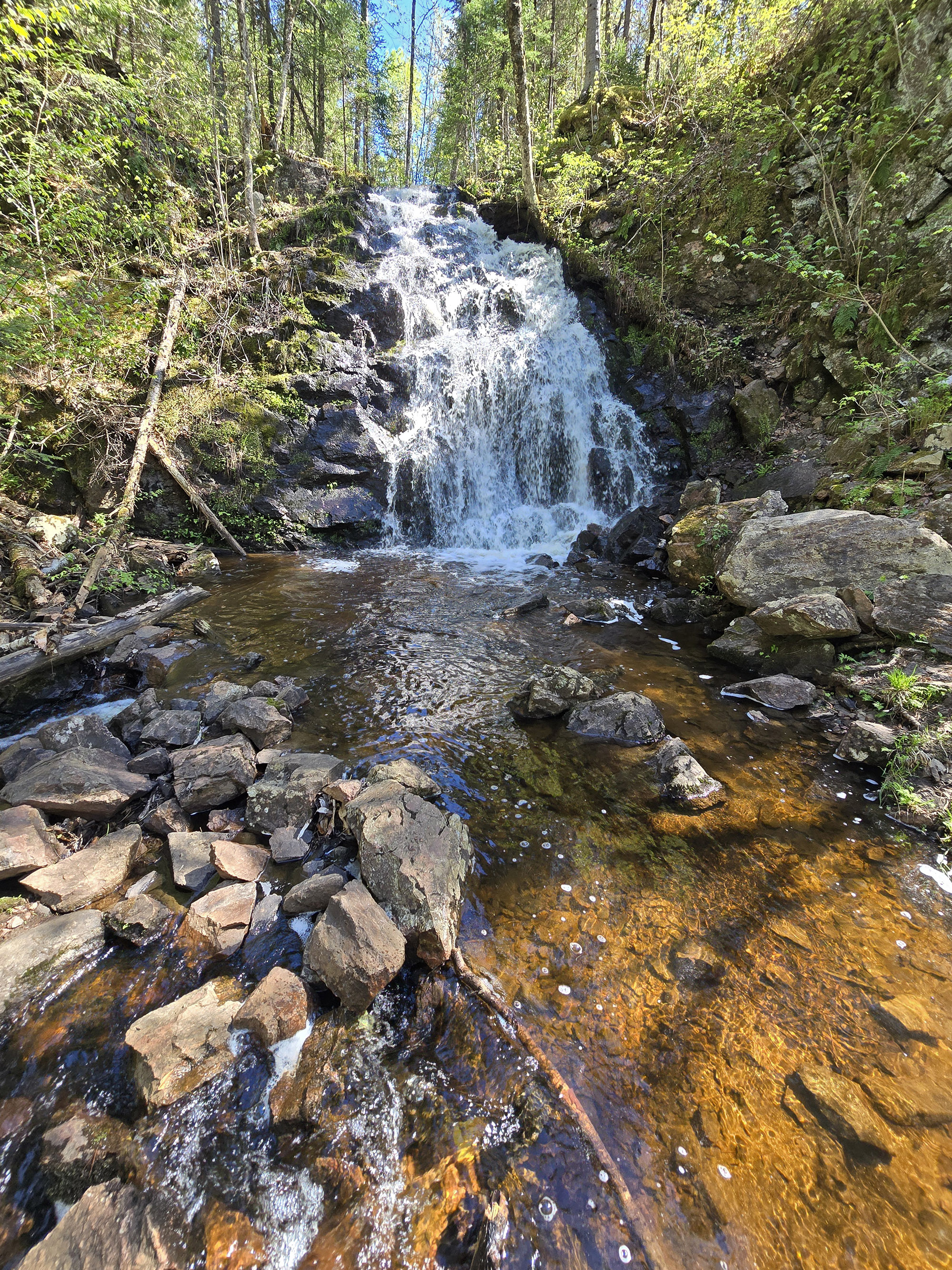
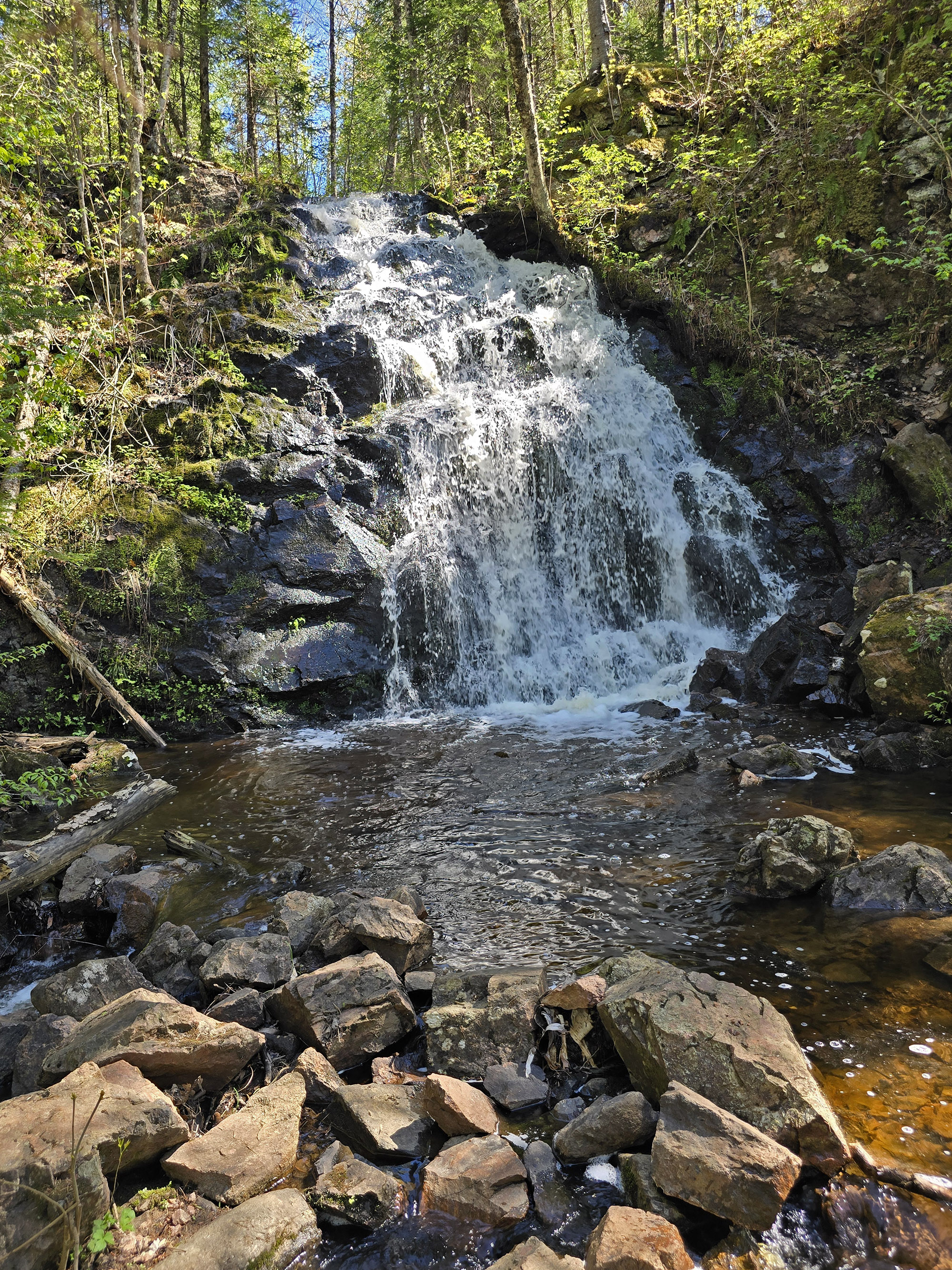
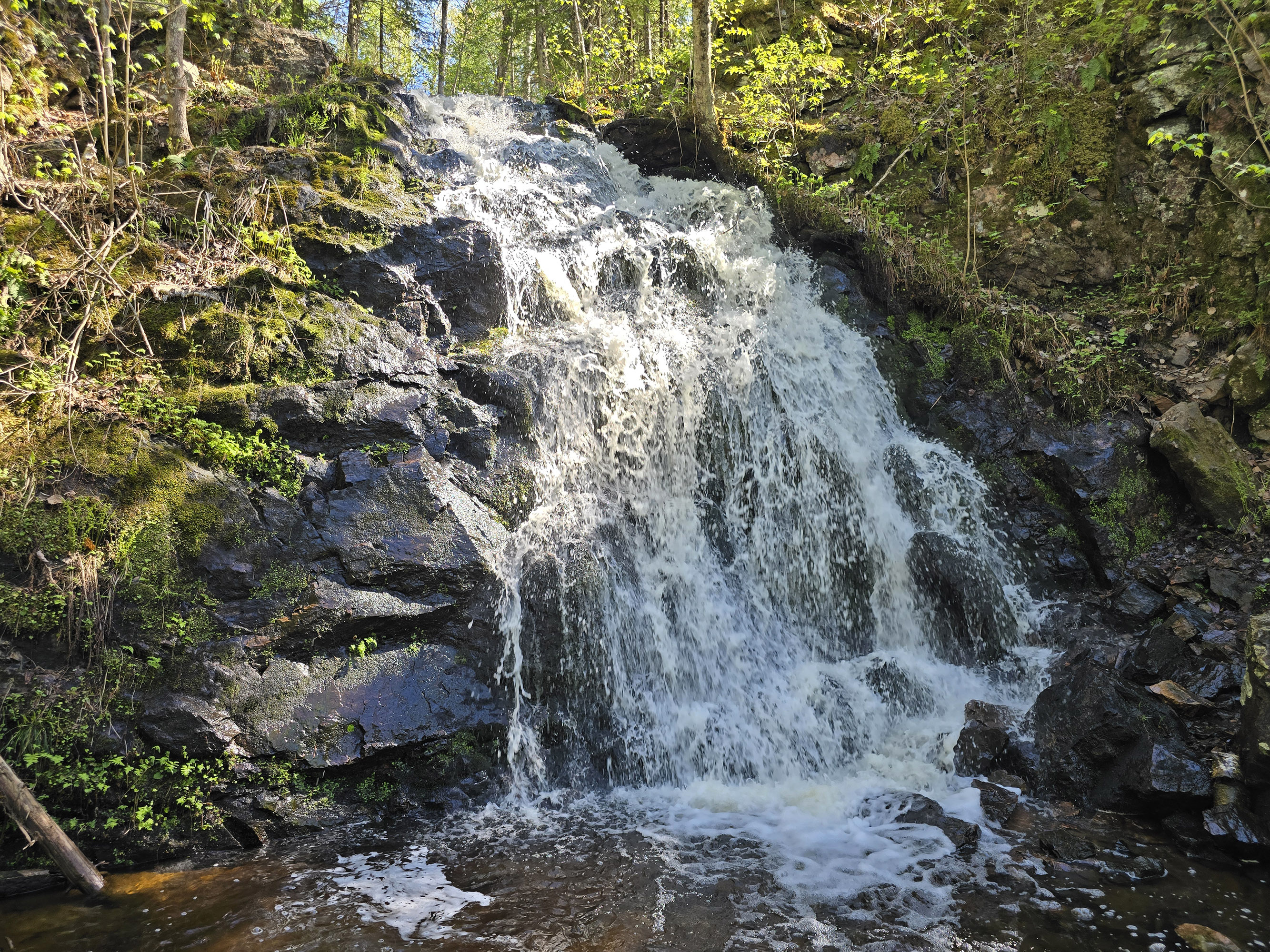
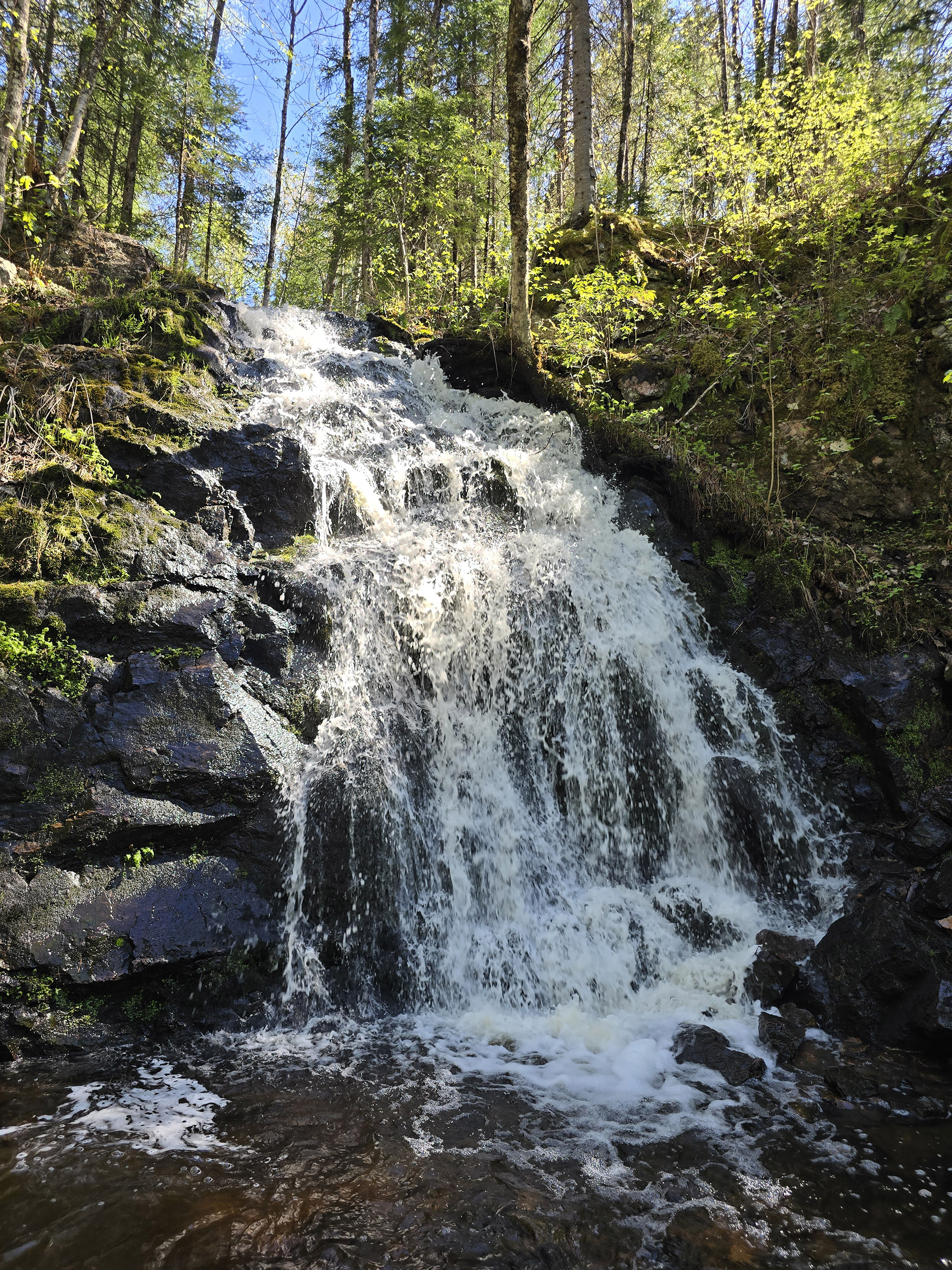
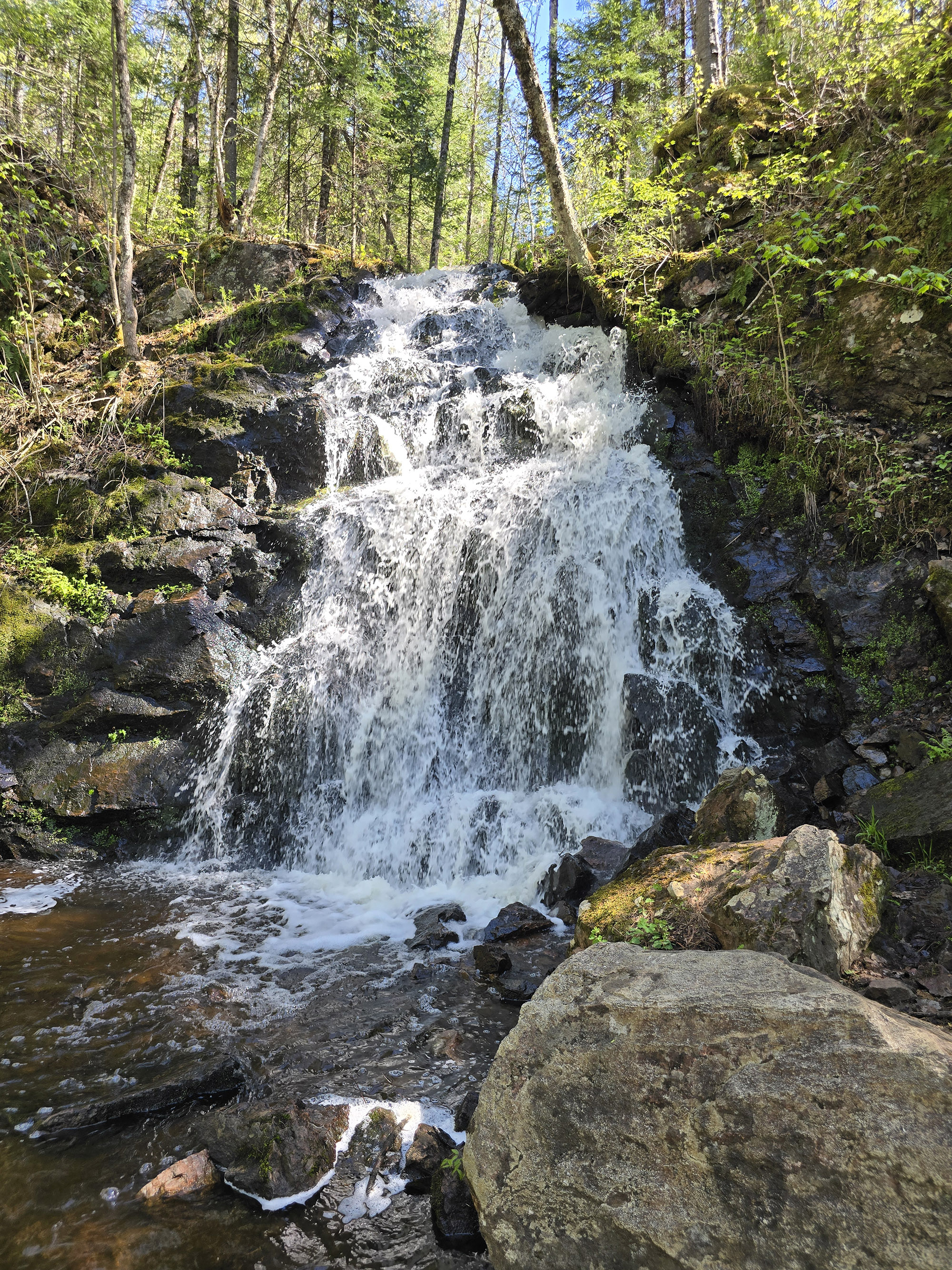
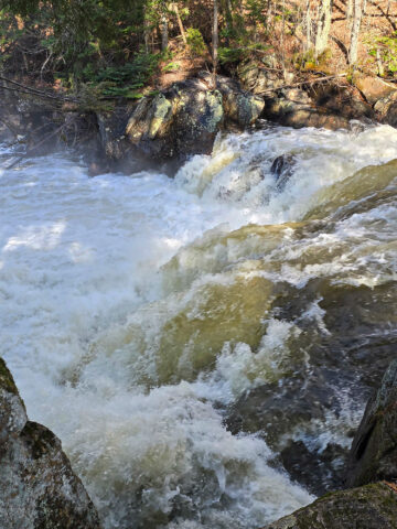
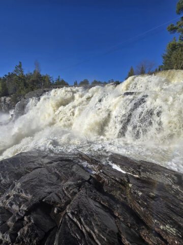
While staying 12 minutes away at Bonnechere Provincial Park in May 2026, we decided to check out Gariepy Creek Falls again.
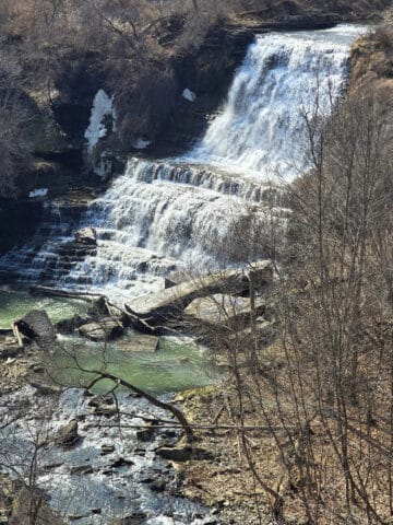
It was spring, after all... and water levels seemed to be pretty high all over the region. We had high hopes to see an actual waterfall this time, and we weren’t disappointed!
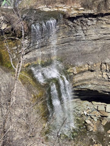
The original photos in this post reflected our first visit - when it was a trickle. I’ve updated this post with the spring 2026 photos, leaving one “trickle” photo for posterity.
As with most falls, this one is better to visit in the spring, than in late summer. This one just takes that whole concept to the extreme!
The Basics:
Location Name: Gariepy Creek Falls
Address: PJG6+4P, Laurentian Valley, ON K8A 0G9
Website: None, as far as I can tell.
Price: Free!
Reservations: Not Applicable.
Maps and Signage
There are no maps or signage at all.
While the falls - as a location - shows up on Google Maps, the trail itself does not.
The parking lot wasn’t marked, we had no idea it was any kind of a trail head when we pulled over.
I just happened to notice what looked to be a trail when I went outside to stretch.
If I hadn’t had Google maps going before we lost connection, I wouldn’t have had any idea that there was a waterfall back there - no road signage or anything.
That said, it’s a straight shot trail to the falls. If you stay on what’s obviously the main trail, you’ll get there!
Parking
The parking lot is unmarked and on the side of the highway - you’ll really want to be looking for it.
It was able to fit our RV and towed car up the length of it, so there’s parking for at least 3-4 cars.
That said, there was no one there during the ~ 2.5 hours we were there.
With it not being a marked attraction on the highway, I’m guessing there’s not a lot of competition for those parking spots!

Connectivity
There was absolutely no cell phone reception anywhere near the falls.
Not on the trail, in the parking, or on the highway for a good distance in either direction.
Accessibility
The trail is not at all wheelchair accessible.
You could do the first part in a walking boot or with a cane - IF you’re ok with stepping over fallen trees.
... but in order to actually see the falls, you’ll have to scale a fairly vertical section of trail that really wouldn’t work for most mobility issues.
I was actually having bad tendon day (across the top of my right foot) and I barely made it back up. I think adrenaline helped out.

Washrooms
There are no washrooms of any kind on site.
Pets
I didn’t see any signage at all about pets, so I would imagine that dogs are allowed.
That last little bit of trail before the falls might be really difficult for them, though.
Share the Love!If you’ve cooked one of our recipes or used one of our tutorials, be sure to take some pics of your handiwork! If you post it, be sure to tag us - @2NerdsInATruck on Instagram, and on TikTok, or post it our Facebook Page - so we can cheer you on! Also, be sure to subscribe to our free email newsletter, so you never miss out on any of our nonsense. Well, the published nonsense, anyway! |
Entertainment and Activity
Some info on what you can see and do at Gariepy Creek Falls.
Hiking
It’s a short hike to get to the falls - probably about 0.4 - 0.45 km. I started MapMyRun a hundred metres or so into the walk, and came in just under a kilometer, return.
The trail starts out relatively wide and well packed, with a bit of a downhill section right away.
There are a couple downed trees and such to walk over - nothing too wild though.

I hadn’t considered that the trail wouldn’t be direct to the falls - it actually starts out kind of parallel to the road, leading AWAY from the falls, then loops back.

Of course, that’s when I started hearing the waterfall.
So, I pressed on.
Right before you get to the waterfall, the trail gets MUCH steeper. It was rough to get down, and I was definitely thankful that I had changed into my hiking boots before checking out the trail.

2026 Update!
Some kind soul has strung some rope between trees to act as a bit of a railing!
It’s a big help for getting down that steep area at the end of the trail.

There are at least two other trails leading out from that clearing (one looked more used, the other looked far more rustic), but I didn’t bother checking them out.
I snapped a few photos, said some choice words to the mosquitos, and hightailed it out of there.

I did get up though, and headed back to the RV.
He was just finishing up with getting the wheel attached, so the timing worked out well!

Biking
With all of the downed trees and the general nature of the trail, I can’t imagine this being a great place for biking.
Swimming
At the time of our first visit, the waterfall was just a trickle, and there wasn’t much in the way of a standing water source at the base.
I don’t know how much more active the stream gets, but - based on the condition of the rocks under the falls - I doubt it sees enough water to be much of a swimming destination.
Now that we’ve seen it at high flow, still thinking it’s not a great swimming spot.
Birding, Wildlife, and Nature
It was an incredibly short trail, and I was trying to get it done as quickly as possible.
Also, Porter was (obviously!) otherwise occupied, so I didn’t have the benefit of his birding camera. (WAY too heavy for me to carry on a trail of unknown difficulty!)
So, between that and all the mosquitos and flys that were looking at me as a buffet, I didn’t do much in the way of birding.
My app wouldn’t load a location, but I heard a crow for sure, at least one Common Grackle, and I’m pretty sure at least one Red-Eyed Vireo.
Pretty much all of the “wildlife” I saw was of the flora variety - especially fungi! There were definitely some cool, unique types of fungus along the path.
There was at least one Ovenbird out at the time of our second visit, though.

Final Thoughts
Well, as far as emergency pull-over spots go, we could definitely have done worse!
Happening across a waterfall and trail like that was definitely a happy surprise - and welcome distraction from the stressful situation.
It was also a nice excuse to get out of the RV and stretch my legs, on what was a fairly long stretch of driving.
That said, the falls were ... underwhelming. If I’d made a point of driving out there to see them, I definitely would have been disappointed.
As an update, it’s definitely worth a little bit of a drive *when it’s at a good flow rate*. After the winter thaw and spring rain, it’s gorgeous!
I’m so glad I was able to take Porter to check it out, given that he missed out the first time. While I wouldn’t make a LONG dedicated trip for it, it’s definitely decent as a rest stop option.
Way more scenic and active than pulling over at a random picnic area, after all!
More Ontario Waterfall Posts
Looking to waterfalling in Ontario? Here are more Ontario Waterfalls to check out:
Albion Falls
Aguasabon Falls
Bridal Veil Falls, Manitoulin Island
Brooks Falls
Buttermilk Falls
Chippewa Falls
Devil's Punchbowl
Eugenia Falls
Falls Reserve Conservation Area
Felker's Falls
Healey Falls
High Falls [Muskoka]
Hogg's Falls
Indian Falls Conservation Area
Inglis Falls
Jones Falls
Kakabeka Falls
Kap-Kig-Iwan Provincial Park
Little Davis Falls
Little Falls Scenic Lookout, Atikokan
Mink Creek Falls
Onaping Falls
Oxtongue River-Ragged Falls Provincial Park
Provoking Falls
Rainbow Falls
Roy Wilson Suspension Bridge
Sand River Falls
Sauble Falls
Scenic High Falls
Sherman Falls
Smokey Hollow Falls
Tew Falls
Tiffany Falls
Walter's Falls
Webster Falls & Spencer Gorge Conservation Area
Webwood Falls
Beyond the beautiful waterfalls, be sure to check out our Places to See category, to find more interesting Ontario places to explore!
We also have a long list of Campground Reviews, and a ton of Camping Recipes to cook up, while on your adventures!
Thanks for Reading!If you loved this post - or have any questions about it - please leave a comment below! We'd also love it if you would consider sharing the link on social media! |
Leave a Reply