
Rushing River Provincial Park is a hidden gem of a campground, located near Kenora. Here's our review of the park, and full camping guide!

We were waiting on a replacement spare tire to come in, so didn’t know how long we’d actually been in the area. “5-10 days” is a BIG window, when you’re dealing with a jam-packed road trip schedule in the summer months!
We figured we’d take our luck at Rushing River park, because hey - waterfalls! It could be a great place to hole up for a few days, and it was only about 20 minutes southeast of Kenora. (We were waiting on Canadian Tire in Kenora.)
As with the last two parks, Rushing River Provincial Park is located in the Lake of the Woods region.
Named after the series of cascading rapids that run through the park, it DEFINITELY seems to be a family-friendly park. After almost-empty campgrounds at Caliper Lake and Sioux Narrows, we were a little shocked to pull up to an almost full, bustling campground.
It’s just 30 minutes from Sioux Narrows!
Anyway, despite being a pretty small park, there is a LOT to talk about here... so let’s get right to it!

The Basics:
Campground Name: Rushing River Provincial Park
Address: Unnamed Road, Kenora ON. Click here for Google Maps location.
Website: https://www.ontarioparks.ca/park/rushingriver
Price: Ontario Provincial Parks uses a pricing matrix across all their parks. See 2025 Camping Fees for more details.
Reservations: Ontario Parks Reservations
Park Classification: Recreational
Season: May 15, 2026 to October 13, 2026 for camping, January 1, 2026 to December 31, 2026 for Day-Use.

Logistics
Some basic information to help you plan your stay at Rushing River Provincial Park:
Registration and Check In
While we had originally booked our campsite reservations at 7am, 5 months to the day before we intended on arriving, that got pretty mangled on the way.
I changed our reservation a couple of times, and ended up essentially booking our spot the day we arrived. By that time - arriving on a Saturday - there weren’t a TON of available spaces. That said, there were still great spots in a few different areas, so we chose a suitable spot, close to the main beach.
While there is a drive-up window for check in, no one was at it when we showed up, so we went inside the park office. The window was staffed at other times during our stay, so maybe someone was just on break at the time.
Check in was fast and friendly as always.
Despite having pre-registered, we still had to actually check in: it’s a SEMI-paperless permit park. No printed permits for your RV or site, but they do print you one for your driving vehicle.

Maps and Signage
The park map is an 11x17 sheet with the map and some advertising on one side, and a few bits of park information on the other.
I like that it actually lists the hiking trails on the map sheet - along with distances and a small amount of info about each. Aside from the very start of them, the 3 main hiking trails aren’t actually shown on the map, though.
Like Sioux Narrows, this map seemed to be different from most Ontario Provincial Park Maps. Not as hand drawn/artsy as Sioux Narrows, just... different.
It was black and white - on a page with full colour ads? - aside from the words “Site Breakdown”, a little section saying that thick lines indicated pavement/thin lines were gravel road, and the legend.
A little odd, but the info was easy enough to read, so no big deal.
One weird issue: None of the parking is indicated on the map.

Once you go through it with a map once or twice, you should be good to find your way around, either way.
One thing we really liked was that - at a certain point on the main road in the south campground - there’s a sign that said “no large trailers past this point”. Always a good thing to actually warn about!

Waste & Water Services
There is a single trailer sanitation station in the park, towards the park entrance. You DO have to go into a campground - past a playground, amphitheatre, and museum - to get there, though.
As a note: You’ll definitely want to keep an eye on the map, as there are a few converging roads in the area, and the signage isn’t amazing.
Anyway, it’s basically the end of a campground loop. It starts with the potable water fill station - threaded connection - then continues on to the dump platform.
This is a single lane, one-way, with no bypass lane... but traffic doesn’t get directed down there, aside from those using the station. The fill and dump stations are both on the driver’s side.
Also of note: there’s a post with hand sanitizer at the dump platform! Not only is the dump platform AFTER the fill, they actually stock sanitizer there - LOVE this!

Connectivity
On Rogers Wireless, we found our cellular reception to be relatively spotty at Rushing River Provincial Park.
It was USUALLY OK at the campsite (we were near the playground) and at the main beach, but really hit and miss everywhere else. There was basically no reception at the front of the park or on the larger trails.
Accessibility
Rushing River Provincial Park is a bit of a weird one for accessibility. The main accessibility issues are mostly all ones that could be solved with a few minutes of effort.
First off, the park office and comfort stations are legitimately barrier free. Well, at least the comfort station by the main beach - the second comfort station is in the north campground, which was gated off during our stay.
The thing is, the only 2 barrier-free campsites (#290 & #292) are located in that section... and it doesn’t open until July. IMHO, it’s kind of crappy to have those two sites located in the section that has a wildly truncated season.
Next, there’s no accessibility information on the map. There are no barrier-free symbols on the comfort stations; if any of the outhouses are accessible, THOSE aren’t marked, etc. There’s a single disabled parking spot at the main beach, and - you guessed it - that’s not indicated on the map.
Information is an accessibility issue, and LACK of info is a barrier.
The disabled parking spot at the beach is located such that you need to go around to the main parking (10 minute limit parking) to get to the path... and there were picnic tables placed halfway on that path, at the time of our stay.
... and that brings me to my trails rant.

The Trails
The hiking trails are wildly under-rated. The two longer ones that are designated “easy” are definitely moderate, the entire way.
“Easy” tends to mean trails that are not only short (and not necessarily short), but are flat and even enough that people with mobility issues should be able to do them. As my husband puts it, “Trails that you could wheel a stroller through”.
I’m not sure I’ve ever seen an “easy” designated trail that’s involved stairs at all, much less stairs, climbing rock faces, constant rocks and roots, hills, etc.
We wanted to take a nice “easy” walk before the local forest fire smoke really set in, so we did the Beaver Pond Trail. I wanted to die by about halfway, and ended the trail in tears from the screaming pain.
My tendons were definitely not up for a moderate hike, and the only reason I pressed on at the beginning was because I knew it was rated easy. I thought maybe they took liberties like “there’s a little bit of difficulty at the beginning, THEN it’s mostly easy”.
That was not the case, and it was a really crappy way to spend the morning ... and the next day or so recovering from! So unnecessary - literally just an accurate designation would have prevented it.
*Accurate* information is an accessibility issue!

Pets
Like the last few parks we’ve been to, there are no designated areas for pets (off-leash dog parks, beaches, etc). There’s also no mention of pets on the site, and we didn’t see any signage.
So, at the bare minimum, I would expect the base rules to apply:
Never leave your dog unattended, or allow it to cause excess noise or harass other campers / wildlife. Keep it leashed at all times, pick up after it, and properly dispose of the droppings.
Also note: The trailer equipped sites that have the 27' travel trailers - #403 and #405 - allow dogs.
Parking
As previously mentioned, none of the parking spots are shown on the map, which is weird. So, a few things to keep in mind:
1. There’s a small pull-off parking spot for a trailer next to the picnic shelter/rapids area, on the way out of the park.
2. There are a few parking spots at the main beach, but there’s a 10 minute limit.
3. There’s no designated parking area at the trail head for Beaver Pond / Granite Knoll Trails.

Miscellaneous
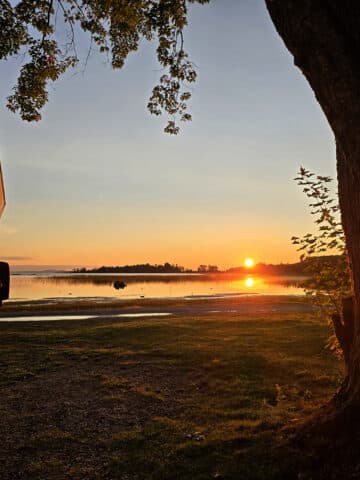
The main beach is more or less north facing, and would be a fantastic place to watch the northern lights, IF you’re lucky enough to be visiting when the conditions are right.
There was a lot of really big aurora activity during our stay... but most of it happened either during broad daylight, or when the sky was blotted out by wildfire smoke. 🙁
On one night, the forecast looked like the sky might clear overnight, so we went to bed early and set an alarm for 1:30 am. Nothing.
So we set the alarm for 3:30 am. The cloud cover map looked bad enough that Porter didn’t figure we should bother getting out of bed.
Just for the hell of it, I took a quick cell phone photo out of the bedroom window, because the sky looked brighter than it should have. Sure enough, I got a crappy photo with a bright green streak through it.
So we raced to get dressed and grab equipment, and I made it out a few minutes ahead of Porter. As soon as I stepped outside - with a headlamp on high to see where I was going - I could see the entire sky filled with bright green streaks, visible to the naked eye OVER my headlamp!
When I got to the front of the RV, I happened to look south - and there was a WILD aurora there. Zenith to treeline bright green curtain aurora, bright as day, with big waves.

Right: The view SOUTH, without adjusting settings 🙁
I was so stunned, I forgot that I was carrying a camera. I grabbed a quick photo with whatever the setting happened to be on (Not the right settings, did NOT do it justice!) ... then it died down.
Porter managed to see about a minute of the MUCH muted show, then it was completely gone. Boo!!
Anyway, if you’re a tent camper, there are quite a few sites along the north side of the south side campground that would give AMAZING views, right from your site.
If you’re interested in possibly seeing the northern lights, check out our posts: Aurora Hunting, How to Photograph the Northern Lights, Can I See the Northern Lights Tonight?, and Where to See Northern Lights in Ontario.

Campground Amenities & Info
We visited in May - kind of a shoulder season - so half the campground was gated off, and some of the campground amenities were closed for the season.
Here’s some basic information, though:
Creature Comforts
There are two comfort stations, one in each campground. We didn’t have access to check out the north side comfort station, but the south side one was nice!
It was a modern building, well-kept, with a fair amount of parking, barrier-free access, and even a beverage vending machine (out of order at the time of our stay, though.)
This building has flush toilets, laundry facilities, and showers, while the north side one only has washroom facilities and showers.

There are also several vault toilets located throughout the park, and they seem to be well maintained.

Park Store
There’s a cute little store at the park office, which sells firewood and a smallish selection of Ontario Parks souvenirs and plushies.
There’s also the “North Side Nook” in the gated-off north side of the campground - which is basically their rental office, but also sells hot and cold beverages.
Beyond that, you can get camping supplies and some basic groceries from Rushing River General Store, a small - apparently seasonal - shop about 1 km south of Rushing River Provincial Park.
The park is also only about 20 minutes from the town of Kenora, which has a No Frills, Canadian Tire, various restaurants, Lake of the Woods Brewery, and more.

Visitor Centre
Across from the main beach in the south side campground, there’s a small park Museum - the “Natural Heritage Museum” - and an amphitheatre.
Unfortunately, the museum appeared to be closed during the time of our stay, and there was no programming offered at the amphitheater.
Too bad - we were RIGHT beside that area!
It was refreshing to see such a new looking amphitheatre that was really central, rather than an old, dilapidated one that’s hidden way off in the bushes and out of the way, as many parks have.

Day Use Area
The park doesn’t really have *a* day use area, so much as several of them throughout the park. We didn’t have access to anything in the north side campground, but here’s what we can tell you about the south side day use areas:
The Picnic Shelters / Rapids Area
Near the front of the park, there are 2 picnic shelters - one picnic shelter on either side of the rapids, with a cute foot bridge over the river, joining the areas.
There are a BUNCH of picnic tables on either side of the rapids, though the most popular picnic areas seemed to be right on the rocks, alongside the rapids.
Gorgeous views ... but it was definitely very busy on the weekend! During my first visit to that area, there were so many people hanging out on the bridge, I couldn’t cross!
There is a small washrooms building across the street from the south side picnic shelter.

The Main Beach
Shortly after entering the park, you’ll come to the main beach area. It’s right at the junction of road that splits off between the north side and south side campgrounds.
There are 2 small beaches here, and it’s across the road from a large playground. There’s a change house, and it’s right next to the south side campground’s comfort station, with showers and flush toilets.

There’s also a small set of rapids nearby, with another bridge (shared with vehicular traffic) in that area. Just a really nice place to chill, or to wander around and look at the water.

Rentals
Weirdly, it seems like only one of the two picnic shelters can be booked online - the north side one. Not sure what the deal is with the south side one, but the park rents out BBQs that can be used at either of them.
Beyond that, you can rent kayaks and water bikes from the front office, as well as the North Side Nook when it’s open for the season.
In terms of loan items, they have extension cords and life jackets available, with a refundable deposit.
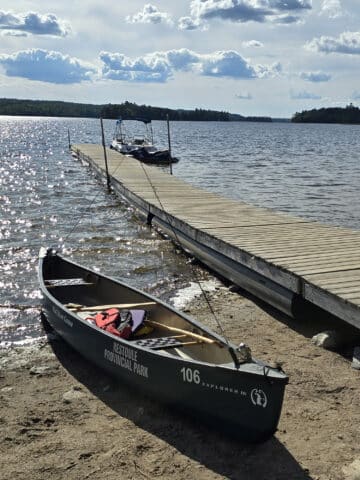
Weirdly, the park will rent you canoes for 3 days or more, to use on the canoe routes... they just don’t offer short term canoe rentals.
For that, you need to go to the Rushing River General Store - and they’ll deliver to the park.

Campsite Details
For such a small park, there is a WILD variety of camping styles available. Rushing River Provincial Park offers both non-electrical and electrical sites, some large sites for trailers, a bunch of smaller tent sites - some with AMAZING views, walk-in sites, and group sites.
It’s also the first park we’ve seen that offers roofed accommodations in the forms of trailers!
As always, each campsite comes with a fire pit and picnic table. Beyond that, here’s some info:
Car Camping
We stayed next to the museum, and this area very much felt like a family campground. It was big and open, with easy walking access to the museum, amphitheatre, beach, comfort station, etc.
Most of these sites seemed to have electrical service, but not much in the way of privacy. The section of this campground that was closer to the office was VERY packed during the beginning of our stay.
Heading outward from there - sites numbered in the 40s to lowish 100s - you get to smaller sites, with more privacy. These tend to be pretty rocky, and most of it is located in a section that you’re not supposed to bring RVs through.

Much like with Sioux Narrows... some of these sites definitely made us wish we were tent campers!

Walk-In Camping
Some of the campsites at the far end of the south side campground (and I’m assuming some on the north side campground!) are walk-in sites.
Each involves a short walk (20-50 metres, per the site) down to the campsites - a lot of which seem to be right on the water. Gorgeous!
Note: There is VERY limited parking for these sites.

Roofed Accommodations
Rather than the cabins or yurts we’re used to seeing at other Ontario Provincial Parks, Rushing River has a unique offering - trailer equipped sites!
There are four of these sites in the park: 400 & 401 - which have pop up tent trailers - and 403 & 405, which each have a 27 foot long travel trailer.
Both types have electricity, propane, a fridge, and stove, while the travel trailer sites also have a freezer and a sink with running water. In both cases, campers have to bring their own dishes and bedding.
All of the trailers have a 2-3 night minimum, depending if you’re booking over a long weekend or not.
Also good to note: Sites #403 and #405 allow dogs - The pop up tent trailers do not - and smoking is prohibited in ALL of the trailers.

Group Camping
There are a few group campsites available to rent, each of a different size and with different features:
#501: This one is a waterfront site, right at gate that was blocking off the north side campground. It’s located down a set of stairs - about 100 meters from the limited parking and a couple outhouses - and can accommodate up to 20 people. There’s water access - more of a canoe launch area, than a swimming beach - and it’s a pretty cute site.

#503: This one is right next to the rapids and one of the picnic shelters, as well as the little foot bridge over the rapids. It’s also the biggest group site, and can handle up to 50 people.

Bottom: Group Site #503
Share the Love!If you’ve made one of our recipes, be sure to take some pics of your handiwork! If you post it to Bluesky, be sure to tag us - @2NerdsInATruck, or you can tag us on TikTok, if you’re posting video. We're also on Pinterest, so you can save all your favourite recipes and park reviews to your own boards! Also, be sure to subscribe to our free email newsletter, so you never miss out on any of our nonsense. Well, the published nonsense, anyway! |
Entertainment and Activity
For being such a small park, there’s actually a LOT of outdoor activities you can engage in at Rushing River Provincial Park.
Here are your options:
Hiking
There are 4 nature trails in Rushing River Provincial Park:

Beaver Pond Trail - 1.1 km Loop
The park has this marked as being easy - that is ABSOLUTELY not the case. It starts out with stairs taking you down to a pine forest, then across a short boardwalk before hitting the rough stuff.
There are a LOT of rocks, hills, roots, etc - be sure to wear proper hiking shoes on this trail, even with the “easy” rating!
Anyway, much of this trail was through the forest, with a couple offshoot lookouts to the lake or wetland.
The point at which the Granite Knoll Trail is NOT clearly marked - the trail makes it seem like it goes across the bridge by default. In reality, you need to go down a less-visible trail to the right of the bridge, to keep to the Beaver Pond Trail.
Overall... it was kind of hard to enjoy this trail, even though it would have been a lovely hike *had we known what we were in for*. I was in a ton of pain, Porter was a bit grumpy because he had planned for more of an easy stroll than a hike, and the namesake beaver pond was an incredibly short section of the trail.
We didn’t even get to see any Great Blue Herons or anything! Definitely some lovely views, though.

Granite Knoll Trail - 2.7 km Loop
This trail is listed as being 2.7 km on the park website, but 5 km at the start of the trail, after the bridge. As it turns out, it was more like 3.5 km in reality.
One thing to note: It’s at the far end of the Beaver Pond Trail loop, so you’ll need to add just over 1 km for that... plus any extra you’ll need in order to get there, due to the lack of parking.
Due to my earlier debacle on Beaver Pond Trail, Porter did this one by himself. Here’s what he had to say about it:

Some are even via mini peninsulas, granting you a great panoramic view of the lake and its little islands.
There are sections that are flat and grassy, narrow with bushes leaning into the trail, and steep rock, but most of the trail is rough rocks and/or tree roots. You definitely need to watch your step, which is why I rate this as moderate difficulty.”

The views on the Granite Knoll Trail are definitely better than the views on the Beaver Pond Trail.
If you're going to do the Beaver Pond Trail, I definitely recommend adding this extra hike on, or at least going in a few hundred meters to enjoy the first couple of rocky outcrops at the water.”

Lower Rapids Trail - 1.8 km Loop
Porter did this trail by himself, which is described as following an old portage route along a series of rapids.
The park has this one designated as easy, in reality it’s a moderate. It’s also 2.14 km, rather than 1.8.
Anyway, here’s what he had to say about it:

The trail starts off as a narrow path through bushes, leading to a mature forest, following alongside the Rushing River. There are outlooks with great river views all along the trail.
There are many tree roots growing across the trail, and lots of areas with short inclines, and many areas of boardwalk bridges and stairs. This makes me call it a moderate trail, since you have to watch your footing in a lot of spots, and combined along the trail there are a lot of stairs and inclines.”

Overall it's a nice hike with a bunch of great views, but then at the end you have to cross the highway again. This time you have to step over the guardrail, there's no opening.
On the other side of the highway you're supposed to hop the guardrail again to walk across a nice pedestrian bridge, but I opted to just walk the short distance on the shoulder of the highway since no cars were approaching.”

Pine Ridge Trail - 500m Linear
This trail is marked as being easy, but the first bit of the trail was WAY too steep for me, so Porter did it by himself.
His review:
“This little ½km trail goes from roughly the beach area to the front of the Rushing River pathway. It's a moderate difficulty hike, with some steep hills and rocky terrain.
For most of the trail you can see road, parking lot, or buildings off to the side, since you're walking along a narrow strip of land between roads.
There isn't much point in this trail, as the views are much better walking along the Rushing River pathway, which runs parallel to this trail.
I think this is a perfect little area for kids to explore that happen to be just the right age. Old enough to be allowed to do some things on their own, but perhaps not old enough to walk a full trail in the deep woods alone.
There's absolutely no way to get lost on this trail, it does branch out in the middle but overall it's not wide enough to get lost.
For experienced hikers, I definitely recommend the other trails, skip this and enjoy the Rushing River instead.”

Biking
There aren’t any dedicated bike trails in the park - and the hiking trails definitely aren’t suitable for biking on.
That said, the park welcomes campers to bike on the campground roads. Not sure I’d recommend it on the weekends, as the traffic was pretty chaotic!

Swimming
There are four sandy beaches at Rushing River Provincial Park, though one was completely inaccessible at the time of our visit (that whole section of the campground was gated off), and 2 of the 3 remaining are right next to each other.
I’m a little confused as to the rules on the main beach we went to, though.
The beaches each have a roped off section, and that’s where we saw people swimming. We were at the main/central beach area, which is just upstream from some rapids.
So, we assumed they want people to stick to the roped off areas, as a safety thing. It’s too bad, because just a few metres past that rope is a little island. I imagine it would be great fun to swim over and hang out there!
That said, the park’s website says “Rushing River has four sandy beaches with excellent swimming areas, all of which have a shallow roped-off section, ideal for children.”
I’m not trying to play semantics, but that reads to me like the shallow areas *of the swimming sections* are roped off for kids, but that you’re not necessarily confined to them?
Nevermind, I just called to confirm - you are, in fact, supposed to stay within the roped off section.
Well. The swimming area just became a lot less cool - it looked to be less than a foot deep! Boo.

Anyway, there’s also a really small beach in the south side campground:

Birding, Wildlife, and Nature
Birding at Rushing River Park was pretty frustrating! While we heard all KINDS of different species of birds, they mostly kept to high up in the trees, or further back from the roads and trails.
So, we saw quite a few birds zooming by, but didn’t have a ton of opportunity to actually photograph them. Between the lighting, the smoke, and them staying high up... it wasn’t the best conditions for actually photographing birds.
Anyway... Overall, we encountered:
American Crow, American Goldfinch, American Redstart, American Robin, Bald Eagle, Baltimore Oriole, Black-and-White Warbler, Blackburnian Warbler, Black-Capped Chickadee, Blue Jay, Brown Creeper, Canada Goose, Canada Warbler, Cape May Warbler, Cedar Waxwing, Chestnut-Sided Warbler, Chipping Sparrow, Common Grackle, Common Loon, Common Raven, Common Yellowthroat, Downy Woodpecker, Golden Crowned Kinglet, Eastern Wood-Pewee, Hairy Woodpecker, Hermit Thrush, Least Flycatcher, Magnolia Warbler, Mourning Warbler, Nashville Warbler, Northern Flicker, Northern Parula, Ovenbird, Palm Warbler, Pine Siskin, Red-Breasted Nuthatch, Red-Eyed Vireo, Rock Pigeon, Ruby-Crowned Kinglet, Song Sparrow, Spotted Sandpiper, Spruce Grouse, Trumpeter Swan, Veery, White-Throated Sparrow, Winter Wren, Yellow-Bellied Flycatcher, Yellow-Rumped Warbler, Yellow Warbler.

Row 2: Canadian Tiger Swallowtail, Cedar Waxwig, Chestnut-Sided Warbler
Row 3: Common Grackle, Eastern Phoebe, Hairy Woodpecker
Row 4: Hermit Thrush, Magnolia Warbler, Red-Breasted Nuthatch
Boating
Rushing River Provincial Park seems like a great place to be if you’re into boating, kayaking, or paddle boarding.
There are a couple of boat launches in the park - one on the south side, and one in the (gated off at the time of our stay) north side.
The south side boat launch was really nice - the dock was in great condition, and there was even a bench on it, to enjoy the view.

There’s also a dock located at the east side of the main beach, but no launch or road up to it. I guess it’s for people boating in to visit the beach?
Anyway, Rushing River Provincial Park also seems to be a popular base camp for those setting out to explore the canoe routes in Eagle-Dogtooth Provincial Park. Those routes start out at this park and go anywhere from 32 kilometres to 103 kilometres in length.

Fishing
Being in the Lake of the Woods region, it makes sense that fishing is a popular activity at Rushing River Provincial Park.
I thought it would be a great opportunity for us to FINALLY try fishing, but the wildfire smoke definitely kept us inside on the day we would have gone fishing.
Anyway, Lake Trout, Pike, Smallmouth Bass, and Walleye are available in Dogtooth Lake itself, with all kinds of other fishing opportunities located within an easy drive of the park.
Also, there’s a small fish cleaning shack next to the boat launch in the south side campground.
As always, seasonality applies, and you must be licensed to fish. If you need a fishing license, you can get one down the road from the park, at the Rushing River General Store.

Discovery Program
While it wasn’t operational at the time of our stay, Rushing River Provincial Park runs Discovery Programming. It’s just limited to July and August.
Sounds like they do the Exploration Station / Discovery Activity Book thing, along with other events. None were posted at the time of our visit, obviously, but they do it up as a weekly calendar, in-season.
Niantic Games
There are a handful of Pokestops / Pokegyms / Ingress Portals / etc throughout the park, but cell reception can be really spotty. Your best bet for game play is in the central playground / beach area, where there are a few stops and at least somewhat decent reception.

Winter Activities
While the camping season is pretty short, the Rushing River Provincial Park is actually open year round as a day-use park.
It sounds like the office is probably closed at that time, but day use permits can be purchased online, or via a self-serve fee station at the park.
They keep the washroom that’s next to the rapids open throughout the winter months, as well as the parking and picnic shelter in that area.
In terms of activities, they’ve got 18 km of groomed cross country ski trails (both skate and classic). They also allow snowshoeing on the hiking trails, but - beyond that - there aren’t any designated snowshoe trails.

Final Thoughts
This is a REALLY nice campground - we kind of weren’t expecting how nice it was, given the two parks we’d stayed in right before it.
The day use area at Rushing River Provincial Park is probably the prettiest we’ve seen, and there are all kinds of amazing places to picnic near the water. We were also really happy to see a museum - complete with a stocked Little Free Library! - and amphitheatre so centrally located.
We’re really glad that only one day of our stay was on a weekend. We’d grown accustomed to quiet, almost-empty campgrounds on the way to Rushing River, and were utterly unprepared for the chaos of a warm May Saturday at the park.
It cleared out almost completely by Sunday, and was amazing from that point forward. I bet it’s an absolute zoo in the summer - and I can absolutely see why it’s known as a favourite park for families.
I’m not sure we’ll be up in the Kenora area again - I think it’ll largely depend on the parks yet to explore in the area. If we are - and it’s in the shoulder season, not on a weekend - we’ll absolutely be back to stay at Rushing River Provincial Park again!

More Northern Ontario Provincial Parks & Places to See
Want to read some more about the parks we've camped and at places we've seen in Northern Ontario? Here are some more posts!
Northern Ontario Campground Reviews:
Aaron Provincial Park
Agawa Bay Campground, Lake Superior Provincial Park
Blue Lake Provincial Park
Caliper Lake Provincial Park
Kakabeka Falls Provincial Park
Lake Superior Provincial Park
MacLeod Provincial Park
Neys Provincial Park
Ojibway Provincial Park
Pakwash Provincial Park
Pancake Bay Provincial Park
Pukaskwa National Park
Quetico Provincial Park
Rabbit Blanket Lake, Lake Superior Provincial Park
Rainbow Falls Provincial Park
Sandbar Lake Provincial Park
Sioux Narrows Provincial Park
Sleeping Giant Provincial Park
White Lake Provincial Park
Northern Ontario Places to See:
Aguasabon Falls & Gorge
Amethyst Mine Panorama
Batchawana Bay
Chippewa Falls
Kakabeka Falls
Mink Creek Falls
Old Woman Bay
Ouimet Canyon Provincial Park
Potholes Provincial Park
Roy Wilson Suspension Bridge
Sand River Falls
Scenic High Falls
Temagami Fire Tower
Terrace Bay Beach
Want to explore beyond Northern Ontario? Check out our full list of Campground Reviews, Ontario Waterfalls, and other Places to See.
We also have a ton of Camping Recipes to cook up, while on your adventures!

Thanks for Reading!If you loved this post - or have any questions about it - please leave a comment below! We'd also love it if you would consider sharing the link on social media! |


Leave a Reply