
Ferris Provincial Park is a small park and campground in Eastern Ontario. Known for its pedestrian suspension bridge, unspoiled acres of woods, and beautiful riverside settings, here’s what you need to know!

Ferris Provincial Park seemed to fit the bill.
Located in Northeastern Northumberland County, it was a fair amount further away from the cities, and more of a natural environment park, than a party park.
Also, this one sounded like it had a LOT going for it.
It’s known for its pedestrian bridge over the Trent River Gorge, the waterfalls, AND it has over 10 km of trails of trails to explore.
We had a great time!
Oh, and spoilers: No one tried to picnic or camp on our site while we were staying there.
There was absolutely zero drama - well, aside from Blue Jays being sure to tell us all about THEIR dramas, early in the morning.
Let us tell you all about it!

The Basics:
Campground Name: Ferris Provincial Park
Address: 474 County Rd. 8 Campbellford, Ontario, K0L 1L0
Website: Ferris Provincial Park
Price: Ontario Provincial Parks uses a pricing matrix across all their parks. See 2025 Camping Fees for more details.
Reservations: Ontario Parks Reservations
Park Classification: Recreational
Season: May 9, 2025 to October 14, 2025

Logistics
We booked our stay on the Ontario Parks website, about a week ahead of time.
Yes, I’d spent 5 months planning this trip, then at the last minute... decided to shoehorn another park in!
Anyway, while there wasn’t a TON of availability at the last minute, at least we weren’t booking for a long weekend or something.
We were able to secure the last electric site available, and we were good to go!
Registration and Check In
Check in was done in the gatehouse, near the main gate of the park.
It’s a small park office - with a small parking lot - and registration was done inside. Check in was fast, friendly, and easy as usual.
As a note: Like Darlington, Ferris has also moved to a paperless permit system.

Park Map
The park map is the newspaper style type, with two maps on the back page - a park overview map on one side, and the campground map on the other.
Other than the scale seeming a bit wonky - and a few trail offshoots that aren’t on the map - no major complaints with this one.

Signage
The Ferris Park signage is very clear and easy to follow, both for the park roads and on the trails. Even right by the main entrance, there is a big sign pointing you in the direction of all the basics.
This is a very small park, with a really, really straightforward layout. You won’t get lost.
Also: There is some really nice trail signage at the head of each of the trails in the day use parking, with more detail maps, information, etc. The Milkweed Trail doesn’t have this, though.

Waste & Water Services
The trailer sanitation station is an actual poop loop in this park, located near the gatehouse, along the road that leads to the campground areas. It’s easily accessible whether you’re arriving at or departing from the campground.
There is a single dump platform, then a single fill platform - threaded hose. There is no bypass lane.

Connectivity
Our connection was really spotty at our campsite - and intermittent as we drove through the park on the main park roads - but seemed really good along the gorge.
When we had to do some work that really relied on the internet - like uploading photos for the blog - we just went down to the parking lot for the day use area, to do so.

Accessibility
So, straight up - if you’re a wheelchair user, you’re going to want to avoid this park.
Only one of the three comfort stations offers barrier-free access, and none of the vault toilets we saw were accessible.
With the exception of the short trail going from the day use parking to the bridge, *none* of the trails were wheelchair accessible.
The lower part of the milkweed trail (from the end near the Trent River) is possibly accessible, if you have an all-terrain wheelchair.
The easiest trails in the park are still going to be relatively moderate for anyone with any kind of mobility impairment.
I wouldn’t recommend any of them on crutches - and probably not with a cane.
I could have done the Ranney Falls Trail in a walking boot with no problem, the Ranney Gorge Trail would have been doable IF I was feeling particularly motivated *and* if it had been dry for a while beforehand.
Wet ground would absolutely make it impossible for using a walking boot without some sort of grip attached.
The Drumlin Trail System ... I wouldn’t even consider attempting it in a boot.

Pets
Ferris Provincial Park has a large, gated off-leash pet exercise area in the day use area. It looked to be in really great condition, both in terms of the fence, and the groundskeeping.
You can find it off a small trail from the parking lot in between the Raney Falls Trail entrance, and the River Gorge Trail System entrance.
Outside of the off-leash area, dogs have to be kept on a leash at all times.
Also: we saw the CUTEST sheltie on the River Gorge Trail - her name was Gabby.

Parking
Most of the campsites were huge, with tons of parking space included. There are also a few overflow parking lots in the campground area, but they’re not on the map.
There is one parking lot for the bulk of the day use area, including all the major trail heads, the falls, and the bridge.
It’s not huge, but we visited on a sunny summer Sunday afternoon, and there was plenty of parking available.
Miscellaneous
Though not nearly as bad as in Darlington, the main campground roads at Ferris are pretty rough.
It’s a gravel road, with some degree if water damage / potholes in places - and fairly steep in places. Definitely secure your loads and take things slow as you’re making your way through!

Campground Amenities & Info
Here’s what you’ll need to know about the amenities offered at Ferris Provincial Park:
Creature Comforts
There are 3 comfort stations in the campground areas - two in Bedrock and one in Valleyview.
All three have flush toilets, but only the Valleyview comfort station has showers. Also: there are no laundry facilities at Ferris Provincial Park.

The single, 2-stall outhouse in the day use is the only washroom facility outside of the campground areas.
It’s in ROUGH shape and was SO gross when we went in on two separate occasions.
Also: Unless you’re looking at the map, you wouldn’t know it was a washroom. There’s no signage on the outside or leading up to it, labeling it as such.
Our first time walking by, I assumed it was a supply shed or something similar!

Park Store
There’s no standalone park store, but there’s a small park store offering in the gatehouse.
They have some shelving on both sides of the registration office, with the products well organized and thoughtfully laid out.
They had some basic camping supplies, souvenirs, fishing supplies and snacks - including a freezer of ice cream treats.
Visitor Centre
There’s no visitor centre at Ferris Provincial Park.

Day Use Area
The day use area at Ferris Provincial Park is pretty small, and is more like a trail head hub, with some additional amenities tacked on.
It has a completely different feel from most parks we’ve been to, that seem to be sprawling picnic areas, with other amenities tacked on - if that makes sense.
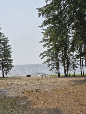
Anyway, there’s a large picnic shelter near the main trail heads, a short walk away from the suspension bridge.
There are also a few picnic tables nearby, near the boat launch, and in random other spots - like one under a tree, halfway along the Milkweed Trail.
Getting to the day use area is a relatively lengthy drive from the campgrounds.
If you want to do it on foot, though, there’s a shortcut that runs though both campgrounds and takes you out to the playground / boat launch area.
That area has access to the River Gorge Trail - and, by extension, the falls and the bridge. We’ll talk more about that trail in the Hiking section, further below.

Rentals & Loans
Ferris Provincial Park has a small rental and loan offering available.
In terms of loans, there’s an all-terrain wheelchair available - a refundable deposit is required.
As far as the loans go, there’s a handful of kayaks available, as well as extension cord rentals.
You can arrange for any for these at the gatehouse.

Campground Details
The campground area of Ferris Park is divided into two campground loops - Valleyview Campground and Bedrock Campground.
Both campgrounds are a mix of electrical and non electrical sites, are open to car camping as well as tent camping, and have similar feels.
Valleyview - where we stayed - seemed maybe SLIGHTLY more geared to RV campsites.
We didn’t measure or anything, but the sites seemed - in general - a bit bigger and longer than the ones we saw in Bedrock Campground. I think Bedrock had more tent-specific sites, and was a bit more hilly... but that’s about it.

I guess that’s why they called it “Valleyview”!
That whole campground loop was set up on a drumlin (an ancient, glacier-formed hill, basically), and was vaulted up much higher than Bedrock.
Also, there was an Osprey nest platform out in the open, between two sites in Bedrock - 125 was one of them, so it’s right near the trail that cuts through to the day use area. (More on that trail in a bit!)

Not in OUR site, mind you... but a fun thing to finally see, either way!

Nevertheless, it was huge and set back from the road, with a good level of privacy. It’s cute, and we always love when the campgrounds have the long driveway / main camping area around a slight curve.
After staying at #102 in Darlington, this was night and day!
Also: There was a pear tree in our site! Super cute, tiny pears... I’ve never seen them so small.

Share the Love!If you’ve made one of our recipes, be sure to take some pics of your handiwork! If you post it to Bluesky, be sure to tag us - @2NerdsInATruck, or you can tag us on TikTok, if you’re posting video. We're also on Pinterest, so you can save all your favourite recipes and park reviews to your own boards! Also, be sure to subscribe to our free email newsletter, so you never miss out on any of our nonsense. Well, the published nonsense, anyway! |
Entertainment and Activity
For such a small park, there’s actually a lot to do and see at Ferris Provincial Park:
Hiking Trails
There are over 10 kilometres of trails at Ferris Provincial Park, many of which have great views.
We did them all over the course of our stay, here’s what you need to know:
Camp Trail
This is a short trail that cuts down from the Valleyview Campground to the Bedrock campground, then kind of continues on down to the boat launch section of the day use area.
Getting down from Valleyview to Bedrock was STEEP. Extremely steep, the whole way - and it’s definitely a bit of distance of steep, at that.
Porter did it, and said that he could definitely see people having a struggle to get back up it. MapMyRun showed it as having 34 metres of elevation gain.
He recommends avoiding that section altogether, after a rain fall. While it wasn’t slippery during his walk, the area has a TON of very clay-based dirt, and we found the other drumlin trails to be really slippery.
That + steep hike = bad idea, IMHO.
Once you get down to the Bedrock Campground, you follow the road around the comfort station, and another trail takes you down to the day use area.
This section is MUCH flatter than the first leg of it.
Anyway, this trail section starts beside the Osprey nest campsites (#125), and goes through a short field of wildflowers. You can exit right at the playground, or hook on to another trail just before it.

Drumlin Trail System - Varying Distances, Difficult
This trail is actually an interconnected set of loops, taking you through mature forest, and up and down some drumlins. These are large hills that were formed by glaciers, thousands of years ago.
The loops are (in order, from the parking lot out):
Blue Trail: 1.2 km
White Trail: 2.5 km
Red Trail: 2.5 km
We did a bit of each trail, but not every section. Also, with the cut throughs and stuff... I’m not sure how or where they’re measuring each trail from.
Expect to do a bit more or a bit less than you are planning on!

VERY quickly, it got steep and rocky.
We followed this to the second white trail access, and looped back to the right, doubling back a little on the first section to see a boardwalk just before the red/white trail intersection at that corner.
The description for the blue and white trails tell you about the Ferris family’s sugar houses, granary, sheep pens, and shingle mill - you won’t see any of that.

Anyway, continuing along the red trail, there is a section that gets incredibly confusing.
The trail dumps you out on what appears to be the Trans Canada Trail, but with no signage telling you where the red trail continues.
We spent a good portion of this section thinking we were somewhere completely different than we were, as the map in NO WAY matches reality, and there weren’t any signs or blazes to help.

By the time we got that far, we were tired, sore, hungry, and frustrated, so we just sort of power walked the rest of the trail.
This trail was pretty difficult, and felt at least twice as long as it actually was. I was SO disappointed when I saw our MapMyRun, saying we’d only gone 4.5 km!
It didn’t seem like it should be as difficult as it ended up feeling, and the heat wasn’t helping!
Anyway, had it been like 10 degrees cooler - and the map/trail markers been more accurate! - this would have been a really enjoyable hike!
As it was... it was really masochistic, LOL.

Milkweed Trail
This is a super basic trail, leading between the overflow parking at the end of the campground road (near the Trent River), and the Trailer Sanitation Station.
There’s no parking at the trailer sanitation station end of it, nor at the little offshoot that takes you out near the entrance to the Valleyview Campground entrance.
So, the main trail entrance is just a short walk up the road from that overflow parking.
There’s no real trail head signage - unlike the other trails - so just look for a well mowed path off to the right.
You’ll walk up a relatively even, wide path for about ¾ of a km. It’s a slight incline most of the way for this length of the trail, through some forest and more open field areas.

There’s a picnic bench under a pretty tree if you’d like to rest a bit, before continuing on the last leg of this trail.
From that point on, the trail gets a fair amount more difficult. It goes through pretty dense woods, with uneven trail, roots, and a moderate incline.
It’s a very ADHD friendly trail, going between wildly different views pretty quickly!

Ranney Falls Trail - 1 km Loop, Easy.
This trail was probably the easiest in the park, with just a short section that was fairly difficult.
The part of the trail that went out from the parking lot to get to the edge of the gorge was pretty basic and uneventful. A nice enough walk through the woods, but that’s about it.
Pretty quickly, you’ll come to a clearing with old park signage - I think this was the part that was the original roadway into the park.
You take a sharp turn there, and start walking along the gorge.
On one hand, it’s frustrating because you can HEAR the roaring water, super close.
On the other hand... hearing the water is a much nicer soundtrack than like... highway noise.
Overall an enjoyable walk, just nothing really to write home about.
Just as the trail turns away from the gorge to head back to the parking, there’s a little - rough - stairway down to a lookout platform.

You can also see the bridge from there, off in the distance. Overall, a spectacular lookout!

From there, you can walk back to the parking lot, or continue along the gorge on a REALLY rough - in places pretty steep, rocky, and difficult - trail that kind of cuts between that trail and the River Gorge Trail.

We actually really liked this little cut through. Yes, it was more difficult.. But it was a more interesting trail.

River Gorge Trail - 3.5 km Loop, Easy
This trail is marked with yellow trail blazes, and overlaps part of the Ranney Falls Trail, near the day use parking lot.
We started this one near the Ranney Falls Trail falls outlook area, and it started out ROUGH - going down over some large rocks, steep areas, etc.

We kept going, and the trail quickly got a bit more challenging. At the first branch, we took it down to the trail walking along the river’s edge, all the way to a bench with an outlook, and then the boat launch area..

Either way ends up taking you through some open field and forests - an easier walk than the section going along the gorge.
That said - at least in summer - you don’t really see much of the gorge, aside from at a few outlook points along the way.
I’d be interested in trying this trail in the fall - I bet the views are spectacular then!

Trans Canada Trail
The Trans Canada Trail cuts through across Ferris Provincial Park’s land, coming in at the Ranney Gorge Suspension Bridge, going up the parking lot and along the park’s main road.
Shortly before the gatehouse, it veers off the road to meet up with the Red Loop of the Drumlin Trail System for a short distance, before veering off out of the park.

So really, if you’re in the mood for a good long hike... the sky’s the limit!
Well, your shoes and body are, anyway.

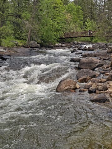
The Ranney Gorge Suspension Bridge
Built by the 81st Airfield Engineering Flight out of 8th Wing CFB Trenton, the Ranney Gorge Suspension Bridge is apparently the only pedestrian bridge of its kind in all of Canada.
It boasts magnificent views of the Trent River Gorge, and connects the park to the Ranney Falls Generating Station.
Also: I bet it’s a spectacular place to view the beautiful fall colours along the gorge, when that time of year rolls around.
Porter calls it a “lot of fun”, I think he’s crazy.

The bottom is a grate style, so you can see right through to the water below. Terrifying. Also, It MOVES.
He really enjoyed it and says it was more stable than he thought it would be, cool view of the falls, really nice view up the other side of the gorge.
There were LOTS of people on the bridge though. If you want to do it empty (as I did, for those failed attempts at crossing!), you might have a long wait on a weekend!

Biking
The park doesn’t have any dedicated bike trails, but offers up the park roadways for cycling.
Also, the outer perimeter of the Drumlin trail system is mixed use, for hiking AND mountain biking.
... I have no idea how anyone could bike on that trail, but hey - it’s available for that use!

Swimming
Due to the dangerous conditions presented as a result of the dam, waterfalls, and the currents that come from that whole set up... you’re not supposed to swim at the park.
That said, we passed an outdoor pool just a few minutes outside of the park, on the way into Campbellford.

Birding, Wildlife, and Nature
We weren’t expecting the wild variety of *everything* we saw during our short stay at Ferris Provincial Park.
In terms of birding, we saw: American Crow, American Goldfinch, American Robin, Black-and-White Warbler, Black-Capped Chickadee, Blue Jay, Canada Goose, Cedar Waxwing, Common Grackle, Eastern Kingbird, Eastern Towhee, Great Crested Flycatcher, Indigo Bunting, Mourning Dove, Northern Cardinal, Northern Flicker, Song Sparrow, Woodthrush
... and we heard: Eastern Phoebe, Eastern Wood-Pewee, Field Sparrow, Hairy Woodpecker, Ovenbird, Red-Eyed Vireo, Scarlet Tanager, White-Breasted Nuthatch, White-Throated Sparrow
Also, there were a couple of Osprey nests, but neither looked occupied.

Row 2: Cedar Waxwing, Eastern Kingbird, Eastern Towhee
Row 3: Indigo Bunting, Northern Flicker, Song Sparrow
There were also a TON of butterflies, especially in the open fields.

We also saw two turtles on the rocks under the bridge - apparently they like to sun themselves there - as well as a snake on the river banks near the boat launch.

Really cool!

(This photo isn’t even all of them!)

Boating
There’s a small, rough boat launch in the day use area near the playground - I wouldn’t launch anything more than a canoe, kayak, or paddleboard.
We saw people on kneeling paddleboards go right up to the falls, that had to be cool.
There were also a bunch of larger boats cruising up the Trent-Severn Waterway, and there are several locks in the area.
I’m guessing there’s some kind of larger boat launch facility outside of the park.

Fishing
We saw a few people fishing in a little clearing near the boat launch area, and some more off boats on the Trent River.
I haven’t seen anything about what kinds of fish are available in the area, though... and it was WAY too hot for us to bother trying our hand at fishing for the first time!

Discovery Program
The park’s website mentions the Discovery Program running in July and August, and that they host an Exploration Station during that time.
We didn’t actually see any information about it during our stay at Ferris Provincial Park.
For that matter - aside from a single baby in a stroller - I’m not sure we even saw any kids during our stay. Weird!
Must be the lack of a beach?
Niantic Games
There are a few Ingress Portals / Pokestops / Pokemon Go Gyms in the day use area, In that area, there are tons of spawn points, and decent cell phone reception to be able to play.
Our first day was on a community day, and we had no problem playing.
Well, except that it was annoying and felt like an obligation, when we really just wanted to see the falls and the bridge!
Nearby Attractions
Campbellford is a really cute town, just a few minutes outside the park. As mentioned earlier, they have at least one outdoor pool, as well as some cute shops, a movie theatre, and pretty parkland areas.
There’s also a giant Toonie!
Our friend Gord advised us that we needed to go to Empire Cheese Co-Operative, and that their 10 year old cheddar would “knock our socks off”.
So, we did. Really cute shop, lots of fun offerings, and we spent way too much money, LOL. That 10 year cheddar IS really nice, though!
I remembered their mint meltaways being good, back when I was in high school and we were selling them for... fashion tech? Maybe through my skating rink? I can't remember.
Anyway, I had to take Porter there, and show him that in this country... even fundraiser chocolate isn't the grainy, gross stuff he was used to in his country, LOL.
Finally, we took a few trips to Healey. Gorgeous little walk, and there IS an Osprey family there.
Be sure to check out our Healey Falls review and photos!

Final Thoughts
We loved Ferris Provincial Park, and would definitely come back. We’re particularly interested in staying on one of the cliffside outlook sites, or the ones near the osprey nest.
Part of what we liked about this park is that it feels WAY more remote than I thought it would, being so close to Toronto. It reminded me of some of the Northern Ontario camping experiences we’ve had.
Even on a summer weekend, it was easy to get a campsite, and things were so peaceful. LOVE it.
I have no idea why no one ever seems to talk about this campground, it’s definitely a hidden gem.
It kind of felt like the equal and opposite to our stay at Darlington Provincial Park, for what it’s worth. Like the universe was balancing things out for us!

More Provincial Park Campground Reviews
Want to read some more of what we have to say about the campgrounds we've stayed at? Here are some more reviews!
Awenda Provincial Park
Balsam Lake Provincial Park
Bass Lake Provincial Park
Bon Echo Provincial Park
Bronte Creek Provincial Park
Canisbay Lake, Algonquin Provincial Park
Chutes Provincial Park
Darlington Provincial Park
Driftwood Provincial Park
Earl Rowe Provincial Park
Emily Provincial Park
Inverhuron Provincial Park
Killbear Provincial Park
Lake Superior Provincial Park
Long Point Provincial Park
MacGregor Point Provincial Park
MacLeod Provincial Park
Mara Provincial Park
McRae Point Provincial Park
Neys Provincial Park
Pinery Provincial Park
Point Farms Provincial Park
Port Burwell Provincial Park
Quetico Provincial Park
Rideau River Provincial Park
Rock Point Provincial Park
Rondeau Provincial Park
Sauble Falls Provincial Park
Selkirk Provincial Park
Sibbald Point Provincial Park
Sleeping Giant Provincial Park
Turkey Point Provincial Park
Wheatley Provincial Park

Thanks for Reading!If you loved this post - or have any questions about it - please leave a comment below! We'd also love it if you would consider sharing the link on social media! |

Leave a Reply